
The City of Boston has one of the finest water supply systems in the country. This series of articles on the history of the system was first published in 1999 in three installments in the Boston Tab and Allston-Brighton Tab newspapers. Then in May 1999, I presented a lecture on the topic at Brighton’s Cleveland Circle Theater under the auspices of both the Brighton-Allston Historical Society and the Friends of the Waterworks, a group that had been working of some years to save the magnificent pumping stations at the Chestnut Hill Reservoir (both a city of Boston and a national engineering landmark) from damaging alteration or demolition. In the following decade, just prior to my relocating to Smyrna, Georgia, I had the honor of serving as the first president of the group, the Metropolitan Waterworks Museum and Reservoir Conservancy, that founded the Metropolitan Museum of the Waterworks in one of the reservoir’s buildings, the Low Service Pumping Station, situated on Beacon Street in Brighton overlooking the Chestnut Hill Reservoir. WPM

Metropolitan Museum of the Waterworks, Chestnut Hill, Massachusetts
Part I.
When Boston’s earliest settlers established themselves on the Shawmut Peninsula in mid-1630, they were attracted to the location, in large part, because of its ample water supply.
Early accounts frequently refer to the “sweete and pleasant” springs on Shawmut. The names that the town government later gave to two of Boston’s oldest streets—Spring Lane and Water Street—attest to the existence of this all-important water supply.
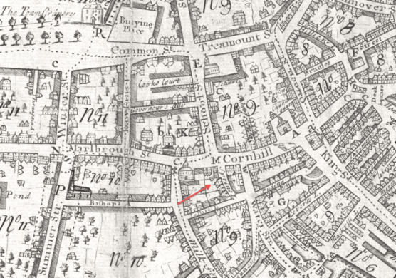
However, as Boston’s population grew over the years—from a mere 100 in late 1630, to 11,000 by 1720, to about 16,000 on the eve of the American Revolution—this surface water supply quickly proved inadequate and residents were obliged to dig wells and to collect rain water in cisterns to meet their needs. In addition, the quality of the town’s water deteriorated. By the middle of the eighteenth century, Boston’s water had become hard, discolored, and offensive to the taste.
The city’s health and safety, of course, hinged the availability of an ample supply of water. Water was needed to combat two hazards—fires and epidemic diseases. The still largely wooden, close-packed town was a veritable tinder-box. No fewer than 15 major fires roared through Boston between 1702 and 1794.
A 1760 conflagration destroyed several hundred tenements, warehouses and wharves. Another major fire, in 1787, reduced more than 100 buildings in the southern part of town.

The devastating 1760 fire that destroyed more than 100 Boston buildings.
Water was also required to keep Boston’s streets clean and thereby reduce the chances of cholera, smallpox, and yellow fever outbreaks in the port city.
The water shortage worsened markedly after 1785 as the city’s population began rising dramatically. From 1785 to 1825 alone, Boston’s population shot up from 16,000 to 58,000 residents. By the 1790s, it had become clear that outside sources of water would have to be tapped for Boston to continue to grow.

An 1870 map of Jamaica Pond, in the present Jamaica Plain neighborhood of the city, Boston’s first major water supply source.
In 1796, the Aqueduct Corporation, a privately owned company chartered by the Massachusetts General Court, was established to purchase the water rights to Jamaica Pond in West Roxbury. Noted civil engineer Laommi Baldwin of Woburn installed a network of subterranean wooden pipes from Jamaica Pond to Boston through which water was conveyed by gravity to subscribers.
Laommi Baldwin, Massachusetts leading civil engineer.
Unfortunately, this system was unable to supply the more elevated sections of Boston, where some of the most elaborate residences were being constructed. Also, the demand for water was growing at such a furious rate that it soon exceeded the capacity of the relatively small Jamaica Pond.
By 1825 there was a consensus in Boston that a new water supply system should be built, but serious disagreement as to the form it should take. Should the system be privately or publicly owned, and how much water should it provide? Also, what sources should be tapped?

John Jervis, Chief Engineer of New York’s Erie Canal and Croton Waterworks recommended Lake Cochituate as the best potential new water source for Boston.
These questions remained unanswered for two decades. Finally, in 1845, Boston turned for advice to John Jervis of New York, the nation’s leading water supply engineer, hoping that his considerable prestige would serve to resolve the water supply debate. Jervis had served as chief engineer of the 363 mile-long Erie Canal, the most elaborate public works facility in the United States. He had also overseen the construction of New York City’s Croton Waterworks System, which was completed in 1842.
Jervis recommended that Boston build an ambitious, publicly owned system that would meet its water needs until about 1870. He further recommended that the supply be taken from Long Pond in Natick (now Lake Cochituate), the same source Baldwin had favored, and that a sizeable holding reservoir be built just outside the metropolis.
Lake Cochituate in Natick, Massachusetts. The building appearing to the left is the original 1848 Lake Cocituate gatehouse.
In March 1846, the Massachusetts legislature approved Jervis’ plan by enacting the Boston Waterworks Act, which established a three member Waterworks Board, and authorized Boston to borrow up to $3 million to carry the plan to completion. In April 1846, Boston’s voters added their approval by an overwhelming vote of 4,637 to 348.
That May the Boston City Council named its first Boston Water Board, consisting of Nathan Hale, James Baldwin (younger brother of Laommi II, and Thomas B. Curtis. The position of President of the Water Board went to Hale, head of the Boston & Worcester Railroad and owner/ editor of the influential Boston Daily Advertiser.
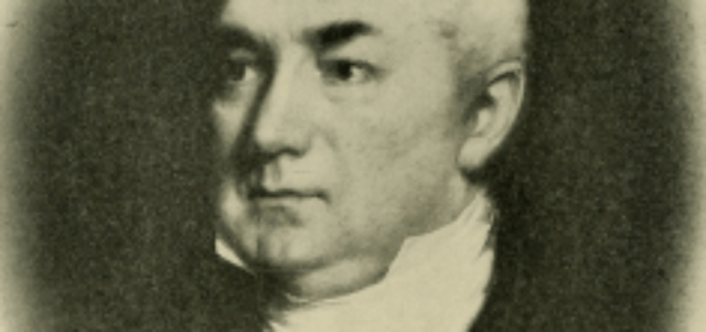
Boston Mayor Josiah Quincy IV
Exercising vigorous leadership at every stage of the of the project was Boston Mayor Josiah Quincy, Jr., son and namesake of the “Great Mayor” who had built the city’s Faneuil Hall Marketplace in the 1820s. Quincy held office from December 1845 to January 1849, from just before the inception of the project until just after its completion. His financial acumen was especially Important to the success of the project.
Ground was broken for the new waterworks at a lakeside ceremony in which the mayor, with the assistance of Josiah Quincy, Sr. and former President John Quincy Adams turned the first shovels of earth. At a reception held just after this ceremony, Mayor Quincy commented that the name Long Pond lacked distinction, proposing that an Indian name, “Cochituate” be substituted, a suggestion that was immediately adopted.

Senior statesman John Quincy Adams, sixth President of the United States (1825-29), and a member of the United States House of Representatives

Josiah Quincy III, known to history as Boston’s “Great Mayor,” joined former President Adams in presiding over the 1845 lakeside ceremony that initiated the Lake Cochituate project.
Under Jervis’ direction, an aqueduct capable of delivering 18 million gallons of water a day was constructed between Lake Cochituate and a receiving reservoir in Brookline (the present Brookline Reservoir), from which pipelines were constructed to several smaller feeder reservoirs in Boston. The project took 26 months to complete and cost almost $4 million.

The Pumping Station at the Brookline Receiving Reservoir.
The introduction of Cochituate water to Boston on October 25, 1848, was a signal event in the history of the developing metropolis, an event celebrated with much enthusiasm and fanfare.
The festivities began at sunrise with a 100-gun salute and the ringing of church bells all across the city. A huge parade then marched through the streets to the Boston Common, where an ode by James Russell Lowell was sung by school children, followed by speeches by Mayor Quincy and Water Board President Hale.
Upon completion of the addresses, the Mayor inquired if the people of Boston were ready for the introduction of Cochituate water into the city. A tremendous affirmative roar from the assembled crowd of 100,000 spectators signaled their assent, whereupon Quincy ordered the gate opened, thereby releasing a column of water which shot up from the center of the Frog Pond to a height of 80 feet.

On October 25, 1848 the Lake Cochituate water supply is introduced into Boston when an 80-foot column of water was released from the center of the Frog Pond on the Boston Common.
Part 2
The decade of the 1850s was a period of extremely rapid growth for Boston, which saw the city’s population increase by over 30 percent. The water needs of this mushrooming metropolis quickly outstripped the delivery capacity of the Cochituate system. The inadequacies of the system became apparent as early as 1859 when a major break occurred in the Cochituate Aqueduct at the point where it passed across the Charles River on the westerly edge of Needham. Since the four storage reservoirs servicing Boston held, at most, a four day water supply, it became necessary to shut off service for all but domestic uses. Had a major fire broken out in Boston at this point the city might have found itself without water, with devastating public safety consequences. The 1859 emergency prompted the Cochituate Water Board to recommend the construction of a much larger storage facility on the edge of th city: the present Chestnut Hill Reservoir.

Circa 1900 century map of the Chestnut Hill Reservoir in Brighton, Massachusetts
It was five years, however, before definite steps were taken to create this expanded storage facility, a delay the Water Board blamed on the poor economic climate of the Civil War period. In 1864, Boston’s City Engineer recommended a site in Chestnut Hill for the contemplated reservoir, on the boundary of Brighton and Newton, land owned largely by Amos Adams Lawrence of the famous textile manufacturing family.

The more westerly of the two basins of the Chestnut Hill Reservoir, the Lawrence Basin, was built on acreage that had been part of the Amos Adams Lawrence estate. The Lawrence family were wealthy textile manufacturers. Lawrence, MA was named for the family. The main campus of Boston College now occupies the heights above the reservoir where the Lawrence residence once stood.
Finally, in April 1865, Governor John Andrew signed a bill authorizing the Cochituate Water Works to “take and hold, by purchase or otherwise” up to 200 acres of land bordered by South Street on the north (now Commonwealth Avenue), Beacon Street on the south, Chestnut Hill Avenue on the east, and an unnamed street “leading from said South Street to said Beacon Street, on the west.” During 1865 this land was purchased, surveys were made, and trees and brush were cleared away. Formal construction did not begin, however, until the spring of 1866.
The building of a formal driveway around the reservoir was proposed during the summer of 1866 and won wide public support. After considerable debate, the water board authorized the construction of an eighty foot wide roadway. Beginning at a great entrance arch, this handsome avenue extended around the northern side of the reservoir where it joined Beacon Street.

The main gateway to the Chestnut Hill Reservoir on Commonwealth Avenue in Brighton. When the avenue was widened about 1905, this gate was removed.
At times the Chestnut Hill reservoir workforce, consisting mostly of Canadian Maritime and Irish immigrant stonemasons, teamsters, and laborers, approached a thousand men. So paltry were the wages paid these workers, however, that in March 1867 the entire force went out on strike. Intent on keeping costs to an absolute minimum, the Cochituate Water Board immediately fired and replaced the entire force. In this era of abundant labor the American worker had little bargaining power. As one historian has written: “His only freedom was to work at the lowest wage and under the worst conditions acceptable to his hungriest rival anywhere, or not to work at all.” The wage at the reservoir in 1867 was $1.50 a day and the average workday of the period was twelve to fourteen hours long.

The Driveway at the Chestnut Hill Reservoir. A ride from Boston to the Chestnut Hill Reservoir was a favorite activity fort wealthy Bostonians of the late 19th century.
In 1868, work was concentrated as much as possible on the smaller Lawrence Basin. It was opened formally on October 26 by Water Board President Nathaniel J. Bradlee, a leading Boston architect, who stated that more than 240,000 cubic yards of material had been removed from the basin. The capacity of the Lawrence Basin was 180 million gallons. It covered 37.5 acres and had a circumference of 1.17 miles. [This body of water was filled in the 1950s by Boston College. Alumni Stadium and student housing now occupy the site.]

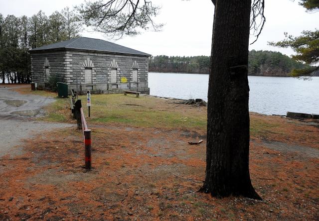
The original gatehouse at the Chestnut Hill Reservoir
During 1870 the larger Bradlee Basin was constructed. This magnificant body of water (the existing reservoir), with a storage capacity of 550 million gallons, covers 87.5 acres and has a circumference of 1.56 miles.

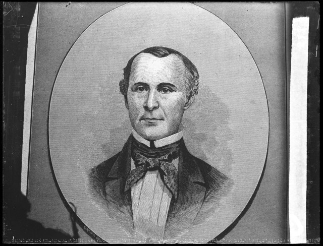
Nathaniel J. Bradlee, noted Boston architect, and President of the Boston Water Board and namesake of the existing Bradlee Basin.
On October 25, 1870, on the twenty-second anniversary of the opening of the Cochituate Water Works, a delegation consisting of President Bradlee, Boston Mayor Nathaniel Shurtleff, and members of the Water Board and Boston Board of Alderman and Common Council dedicated the Chestnut Hill reservoir. In his remarks, Bradlee noted that the cost of the project, $2.4 million, had exceeded expectations, but that “its value is in the security it gives to the life and health of the inhabitants.” The total holding capacity of the completed facility was 731 million gallons.
In the 1870 to 1900 period Boston’s population more than doubled, rising from 250,000 to 560,000 (some of the increase occasioned by the annexation of surrounding cities and towns). The city’s water supply system thus required further expansion. A number of stopgap measures were resorted to in the 1870s to increase the supply, including the construction of six small reservoirs on the Sudbury River and its tributaries, which provided another 13 million gallons for the city. In addition, with the annexation of the City of Charlestown in 1874, Boston acquired the water rights to Mystic Lake, which added 7 million more gallons to its overall water supply.

Frederick P. Stearns, one of the nation’s leading civil engineers, who who extended Boston’s water supply system to the Clinton, Massachusetts area and designed the massive Wachusett Reservoir
By the early 1890s another serious water supply crisis loomed. The Cochituate Water Board predicted that the city would face serious shortages by 1898 unless substantial new sources of water could be found. In 1893 the State Legislature ordered the State Board of Health to investigate the problem and to make recommendations. The upshot was an 1895 report, prepared by Chief Engineer Frederick P. Stearns, which pointed out that Boston’s consumption of water was approaching 80 million gallons a day, while the capacity of the Cochituate system stood at a mere 83 million gallons. The margin between supply and demand was thus growing dangerously narrow.
Stearns advocated a comprehensive approach to the problem that would serve to meet the needs of Boston and surrounding municipalities for the next quarter century. After examining a number of water supply options, he settled upon the Nashua River as the most suitable source. The choice of the Nashua River reflected a reluctance on the part of Massachusetts water engineers to resort to filtrated water. Since the Nashua River Valley was sparsely populated, its water supply would require no filtration.
The Stearns Plan called for the building of a giant dam on the Nashua River at Clinton, Massachusetts, and the creation above the dam of a seven square mile reservoir with a storage capacity 63 billion gallon, enough water to double Greater Boston’s supply.
The Massachusetts legislature adopted the Stearns Plan on June 5, 1895 and created a Metropolitan Water District and Metropolitan Water Board to administer the new system. Stearns was subsequently hired as Chief Engineer.

Here we see a crew at work on the Wachusett Reservoir. The project employed many immigrant workers, including this writer’s great grandfather and his brother, Pietro and Donato Salvucci, both skilled stone masons.
The Wachusett Dam and Reservoir (as the Clinton facility was called) took several years to complete. When it was dedicated in 1906, it was the largest reservoir in the world, and had cost some $21.6 million to construct. It also provided employment opportunities for tens of thousands of workers and acted as a magnet for skilled immigrant labor in a period when immigration into the United States was at an all-time high.

The completed Wachusett Reservoir
The Wachusett project greatly enhanced the reputation of its chief engineer, Frederick Pike Stearns, raising him to the leadership of the engineering profession. In 1905 he was elected President of the American Society of Civil Engineers. Subsequently he planned the 1906-10 improvement of the Charles River Basin and also served as a member of the Board of Consulting Engineers of the Panama Canal.
Two facets of the development of Boston’s water supply system should be emphasized at this point: (1) The sources that the city tapped after 1895 moved progressively further and further west (from densely populated to sparsely populated precincts of Massachusetts where the water was as yet untainted); and, (2) Twentieth century water supply projects, in contrast to those of earlier periods, involved the creation of massive storage reservoirs which necessitated the inundation of whole communities. In the case of the Wachusett Reservoir most of the town of West Boyston had to be flooded. The destruction of rural communities for the benefit of urban populations naturally generated a high degree of outrage among residents.
Part 3
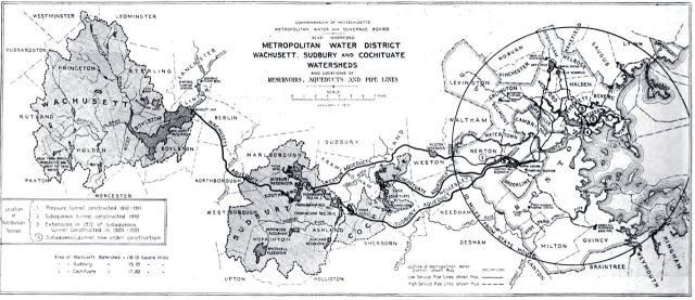
Map of the Metropolitan Water Supply District in 1910
With the completion of the Wachusett Dam and Reservoir in 1908, Boston and the other 18 cities and towns that then comprised the Metropolitan Water District were furnished with a greatly expanded supply capacity, amounting to some 155 million gallons a day.Planners estimated the reservoir would satisfy the metropolitan area’s water needs for 30 years. Their estimate fell far short of the mark, however.
By 1919, a combination of steadily increasing water consumption and the expansion of the district’s boundaries through the addition of new cities and towns had raised the use level in the district, giving rise to renewed concern about eventual shortages.
Two significant steps were taken in 1919 to lessen the danger. First, a new public agency, the Metropolitan District Commission, was created to coordinate water, sewer, and parkland administration in metropolitan Boston. In addition, the State Legislature ordered the preparation of a new comprehensive study of the district’s future water supply needs. Responsibility for preparing this report was shared by the MDC and the Massachusetts Board of Health.
Boston’s water supply planners had long since rejected the idea of using filtrated water. The planning trajectory instead was pushed increasingly westward in a search for new sources of pure water.
The most promising new pure water supply lay some 50 to 65 miles west of the city in the Ware and Swift River Valleys of central Massachusetts. As early as 1895 Frederick P. Stearns, the chief engineer of the Wachusett Reservoir, had identified the Swift River Valley (site of the present Quabbin Reservoir) as having a tremendous water supply potential.
Especially important were two factors: the sheer volume of pure water available there and the basin-like topography of the valley. Moreover there were no major industries on the banks of the Swift River. The valley’s economy had been in the doldrums for years. Apart from some farms and orchards, a handful of small mills and a seasonal tourist industry catering to New York hunters and fishermen, the area was economically undeveloped.
Another great advantage of the Swift River Valley lay in its low population of just 30 people per square mile. Low population density and the lack of industry would, of course, simplify the process of taking land for a new reservoir. Property values were low to begin with, and once rumors began circulating of an eventual government land taking, values fell even more, according to historian Thomas Conuel.
It is easy to see why the Swift River Valley was considered expendable by state water planners. No major businesses would be ruined, no major highways disrupted, no prominent landmarks buried by the waters of Quabbin. The Swift River Valley was a small, out-of-the-way place, totally lacking the political and financial power that could have saved it.
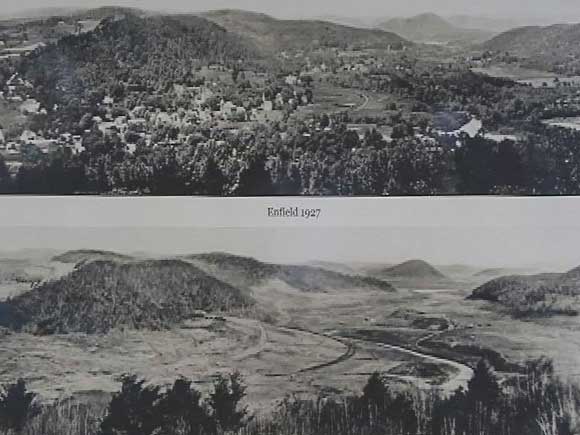
The Town of Enfield, Massachusetts in the Swift River Valley as it looked before and after residents moved out and buildings were buildings were cleared from the site to make way for the inundation of the Swift River Valley and the creation of the Quabbin Reservoir.
While the MDC/ Board of Health Report, which appeared in 1922, recommended that the waters of the Ware and Swift Rivers be tapped by the Metropolitan Water District, the more pressing needs of the city of Worcester and communities in Berkshire, Franklin, and Hampshire Counties and the Merrimack River Valley needed to be addressed first.
Not until 1928 was the first tangible step taken to exploit the Ware and Swift River water supplies. This involved the building of a 12.5 mile long aqueduct connecting the Wachusett Reservoir to the Ware River, a major public works undertaking. A 12 foot wide massive horseshoe shaped conduit , known as the Wachusett-Colebrook Tunnel had to be blasted through solid rock at a depth of 200 feet. The arrival in 1931 of the first water from the Ware River by way of this tunnel probably saved the Wachusett Reservoir from drying up, for a prolonged drought had reduced Wachusett’s water supply to less than 20 percent of capacity.
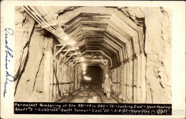
During the early 1930s, the Wachusett-Colebrook Tunnel was extended 10 miles further west to link with the Swift River. This section of the aqueduct, in contrast to the easterly portion, lay entirely above ground.
In the meantime preparations were being made for the removal of the residents of the Swift River Valley. In creating the Quabbin Reservoir four towns—Greenwich, Enfield, Dana, and Prescott—would be overrun by the waters of the Swift River and its tributaries.These town were extensively photographed, their cemeteries were removed and property was purchased by the MDC. The resentment the destruction of these towns generated is still palpable i central Massachusetts today.
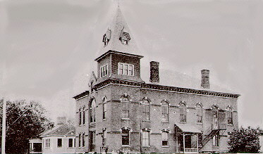
Enfield Town Hall, where an emotional Farewell Ball (described below) was held in 1938
In early 1938 the final residents of the four communities bid an emotional leave to their homes and the associations of a lifetime. The following account, which appeared in the Springfield Morning Union describes the scene in one of the communities, Enfield, as that town passed into history on April 28, 1938:
Under circumstances as dramatic as any in fiction or in a movie epic, the town of Enfield passed out of existence at the final stroke of the midnight hour.
A hush fell over Town Hall, jammed far beyond its ordinary capacity, as the first note of the clock sounded; a nervous tension growing throughout the evening had been felt by both present and former residents and casual onlookers.
The orchestra which had been playing for the firemen’s ball throughout the evening, faintly sounded the strain of ‘Auld Lang Syne’…muffled sounds of sobbing were heard, hardened men were not ashamed to take out their handkerchiefs.
To quote from a recent article published by the Swift River Valley Historical Society, dealing with the extent of the damage done to the historic fabric of the valley towns and their residents: According to a section on the state Department of Conservation and Recreation’s website about the Quabbin, hundreds of homes, businesses, a state highway, a railroad line, and 34 cemeteries were moved or dismantled to make room for the reservoir. More than 6,000 graves were relocated from the Swift River Valley to Quabbin Park cemetery. And more than 2,000 people were displaced.

Winsor Dam, the larger of the two dams that impounded the waters of the Swift River, named for the Quabbin Reservoir Chief Engineer Frank Winsor
The building of Quabbin had begun two years earlier in 1936. The chief engineer of the project was Frank Winsor. First the waters of the Swift River were impounded through the construction of two huge dams at the southern end of the valley. The larger of these, Winsor Dam, is some 2,640 feet long and 295 feet high. Goodenough Dike is 2,140 feet long and 264 feet high.

With the completion of the two dams in 1939, the filling process began, with the shape of the reservoir being determined by the basin-like topography of the valley.
The vast Quabbin Reservoir that slowly rose behind Winsor Dam and Goodenough Dike was 18 miles long and covered and covered an area of 38.6 square miles. The Quabbin Reservoir shoreline is an incredible 116 miles long. At its maximum depth, in front of Winsor Dam, the great reservoir is 150 feet deep, with an average depth of 90 feet at its center.

The completed Quabbin Reservoir
Not until 1946, seven years after the filling process began, did Quabbin reach its capacity, some 412 billion gallons of water. At that point Quabbin enjoyed the distinction of being the largest reservoir in the world devoted exclusively to water supply uses.
Today the Metropolitan Water Resources Authority (which took over the metropolitan area’s water supply system in 1984) services some 2.5 million users in 46 cities and towns. Construction of the Quabbin Reservoir provided the metropolitan district with a vast supply of high quality water, one of the finest metropolitan water supply systems in the nation’s, which it is estimated will satisfy the needs of metropolitan Boston until 2020.
