

Contemporary Map of Brighton Center
#9: Vantage Point: Dighton Street & Chestnut Hill Ave. intersection facing Brighton Square Park
Brighton Square Park: This green space on the opposite side of Chestnut Hill Avenue, now known as Brighton Square Park, is the closest thing that Brighton has to a town common, but it was in fact laid out quite late, in 1871. The lower portion of Chestnut Hill Avenue extending from this intersection into Brighton Center was put through in that year as part of a effort to transform the character of the area just south of Brighton Center from the noisome and odoriferous cattle yard/ slaughtering center that it had been earlier in its history, into an area suitable for high quality suburban development
This site in the Civil War Period: During the Civil War this parcel of land was an annex to the Brighton Cattle Market. The cattle trade of Brighton was then at its height. Like the main cattle market on the north side of Washington Street in Brighton Center, this parcel of land and the hillside to its immediate west was filled with paddocks for the accommodation of the cattle and other livestock that were then being herded into the Brighton Center area on a weekly basis to satisfy the high demands stemming from a wartime economy. The Civil War marked the high point of the cattle trade in Brighton. In its aftermath, demand fell markedly; also with the introduction of refrigerated railroad cars in the late 1860s it became possible to slaughter cattle closer to the chief sources of supply in the west, places like Chicago and Cincinnati, and ship these products to eastern markets. Thus was set in motion a slow but inexorable decline in the local cattle and slaughtering trades that changed fundamentally the economic character of Brighton.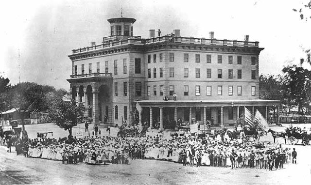
The end of an epoch: The people of Brighton celebrate the end of the Civil War in May 1865 on the grounds of the Cattle Fair Hotel.
The Transformation of Brighton: A group of Brighton entrepreneurs and officeholders, known as “The Brighton Ring,” orchestrated this major transformation in the character of Brighton beginning in the 1870s. These political entrepreneurs had concluded by the early 1870s that Brighton had greater economic potential as a commuter suburb than as a cattle market and slaughtering center. The “ring” was responsible for improved streets, sewerage, lighting, and public facilities, while also raking in personal profits through a series of dishonest land and building projects that increased the town’s indebtedness eightfold in just a few short years. They then persuaded the electors to authorize Brighton’s annexation to Boston as a tax relief measure. While this saved the taxpayers money in the short-run, it meant that Brighton thereafter was lacking in political self-determination, which facilitated haphazard overdevelopment.
As part of this effort to make Brighton more appealing for potential commuters, a number of handsome new public buildings were erected in the triangle formed by the intersection of Chestnut Hill Avenue and Academy Hill Road. These new buildings included:
 The Bennett School, which still stands on the west side of Chestnut Hill Avenue facing the green, a parcel that was long officially known as Wilson Park. The Bennett School was designed by Boston architect J. Foster Ober. Now sadly devoid of its distinctive mansard roof, this structure dates from 1873, the last full year of Brighton’s political independence.

The Chestnut Hill Avenue Fire Station was likewise built in 1873 on a design of another prominent architect, Abel C. Martin. The building, which was destroyed in a fire in the late 1930s,was replaced by the structure that now houses the Veronica Smith Senior Center and the Brighton-Allston Heritage Museum (formerly the Brighton Municipal Building).

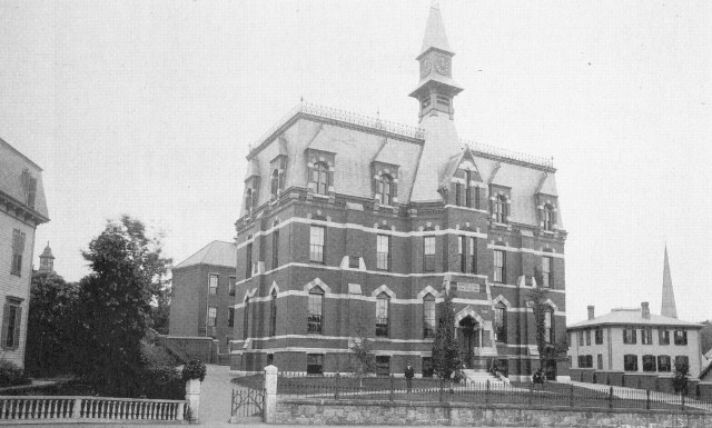
The most distinctive of these three handsome public buildings on the edge of Wilson Park was the Holton Library, also dating from 1873. Brighton’s public library, designed by a native-born architect of national reputation, George Fuller, was named for the library’s original benefactor, local businessman James Holton.

James Holton, benefactor of Brighton’s Holton Library, which stood on the site now occupied by the current Academy Hill Branch of the Boston Public library. When Holton died in 1866, he left a substantial sum of money to the town for the purchase of books for a public library. This collection was first housed in the town hall, and transferred to the new building in 1874.
All of this was extremely costly. In the period 1870-1873 Brighton’s town’s debt increased eightfold, but taxes were intentionally not raised by the town’s wily political leadership who were maneuvering for annexation to Boston. The ring profited personally as well as politically from the many infrastructure projects of the early 1870s—-personally, in that they sold land to the town at highly inflated prices as sites for these new facilities, and politically, in that they were Democrats and the City of Boston, which they favored joining, was likewise dominated by the Democratic Party.
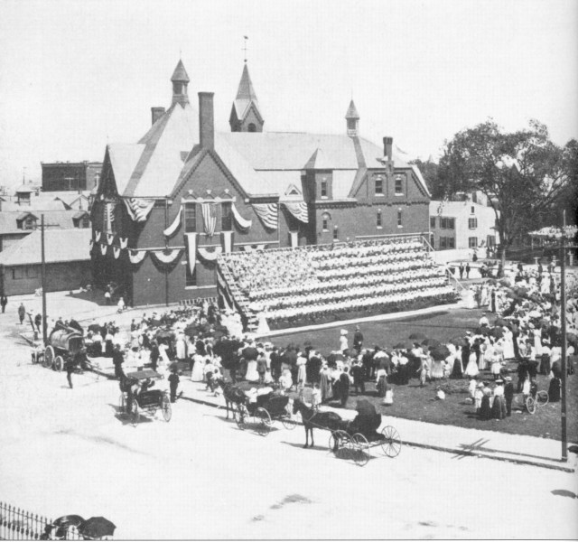 The 1907 “Living Flag” ceremony in Wilson’s Park (now Brighton Square Park) held in celebration of the hundredth anniversary of the incorporation of the Town of Brighton, which had been previously a part of Cambridge called Little Cambridge. The Living Flag ceremony featured the schoolchildren of the town dressed in red, white, and blue costumes arranged on a raised platform.
The Original Winship Slaughterhouse: To the left of the Academy Hill Road intersection with Chestnut Hill Avenue (Rockland Street as it was originally called) stood the very first slaughterhouse established in Brighton by the Winships in 1776 at the time of the foundation of the local cattle and slaughtering industries. No image of this first slaughterhouse is known to exist. The Winship put out a call to the farmers of the general area to drive their cattle to Little Cambridge so that it could be slaughtered to feed the Continental Army.
Stop #10: Academy Hil. Proceed up Academy Hill Road a short distance to the Mt. Vernon Street intersection
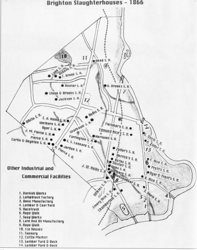
By 1866 there were 41 slaughterhouses in the town engaging in a highly lucrative but also unhealthy and largely unregulated slaughtering practices. The town’s butchers were reluctant to modify their profitable practices of dumping offal and blood into the town’s streams and allowing the unwanted parts of animals to decompose in the open air. As long as the slaughtering industry remained profitable they showed scant showed little inclination to alter these unhealthy practices. By the the middle of the 19th century Brighton had a mortality rate comparable to that of Boston’s inner city slum neighborhoods. While neighboring communities like Brookline and Newton were developing into highly desirable commuter suburbs, the residential population of Brighton consisted largely of cattle dealers, slaughter house proprietors, and others who benefitted from this booming industry.

The Brighton Abattoir,established on the edge of the Charles River in North Brighton, in 1872
Taming Brighton’s Unhealthy Slaughtering and Waste Disposal Practices: All of this began to change about 1870, when the major landowners themselves took the lead in advocating reforms, having recognized that they were more likely to profit from suburban development rather than the slaughtering trade, which after the Civil War had fallen into headlong decline. A turning point of sorts occurred in 1869 when the state established the Massachusetts State Board of Health which called attention to the danger that tainted meat and inadequate health regulations posed to the public. By 1872, the state, with the concurrence of the local slaughterhouse proprietors, passed a law mandating the closing of the many individual slaughterhouses that dotted the town, and ordered the consolidation of the industry in a single modern facility, or abattoir, situated on the Charles River in North Brighton, a facility managed by the Butcher’s Slaughtering and Melting Association, which was effectively a monopoly under their control. This abattoir existed until the late 1950s.
The Thomson House:
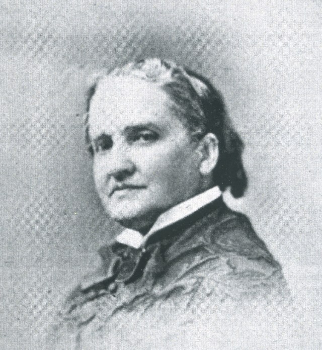 Elizabeth Rowell Thomson, Philanthropist
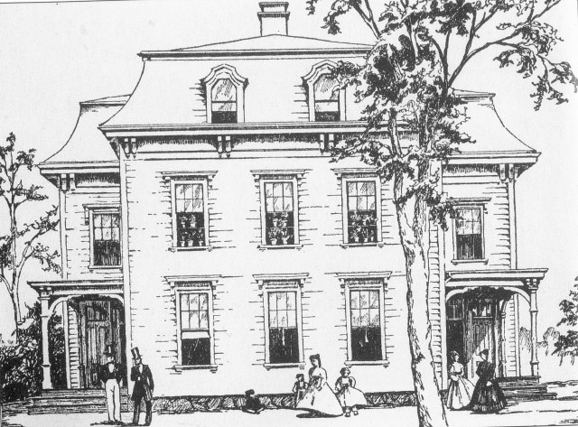
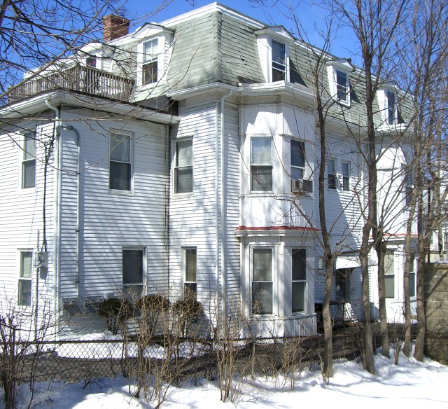 The Thomson House, 7 Mount Vernon Street
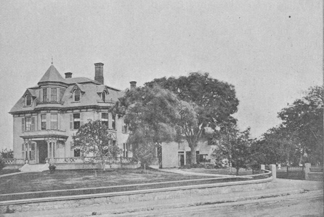
Before the 1899 construction of the Hathaway mansion (covered in part 1) an older house stood on the same site. This was the home in the period 1843 to 1860 of Thomas Thomson and his wife Elizabeth Rowell Thomson. Thomas Thomson was a wealthy, somewhat reclusive, elderly merchant and art collector. When he died his much younger wife inherited both his property and a very substantial annual income estimated at $50,000 to $100,000 annually, a huge sum back then. In the years that followed Mrs. Thomson became a major philanthropist and reformer. Her many charitable contributions included the gift of an observatory to Vassar College, the establishment of two towns in the west for working class families, and a $25,000 donation to the American Association for the Advancement of Science. She also made a gift of the much admired painting “The First Reading of the Emancipation Proclamation” by F. B. Carpenter to the US House of Representatives, and was granted the privilege of sitting on the floor of the U. S. House any time she visited the Capitol, the only woman accorded that privilege up to that time.
In 1897 the Thomson house was moved to nearby Mt. Vernon Street, where it still stands.
 F. B. Carpenter’s celebrated painting “The First Reading of the Emancipation Proclamation” which Elizabeth Rowell Thomson bought for $25,000 and donated to the U.S. House of Representatives.
The Original Brighton High School building located at the top of Academy Hill. This structure had originally housed a private high school, or academy, which gave the street its name.
Academy Hill Road was so named after a private school or academy was established on this hill south of Brighton Center in 1839. In 1841, the town purchased the building to serve as the headquarters of the town’s newly established high school. Brighton, it should be noted, was one of the first towns near Boston to establish a public high school and its school system as a whole was ranked the best in the state Horace Mann’s State Department of Education in the early 1840s.
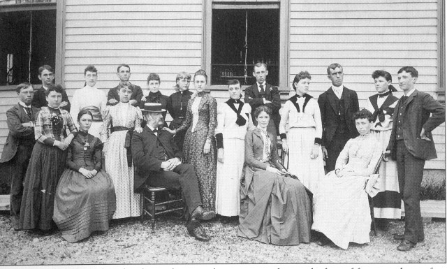 Faculty members and the graduating class of Brighton High School outside the 1866 high school building in 1889.
Brighton High continued at the Academy Hill location until 1894, when it moved to the building that is now known as the Taft School on Cambridge Street, a short distance east of Brighton Center. The present Brighton High School building on Nevins Hill dates from 1929.
 A view of Academy Hill Road looking north from the Peaceable Street intersection about 1890. The white building at the center in the background was the home of wealthy merchant and cattle dealer James D. Wilkins. Behind it, on the crest of Academy Hill, stands the original Brighton High School building.
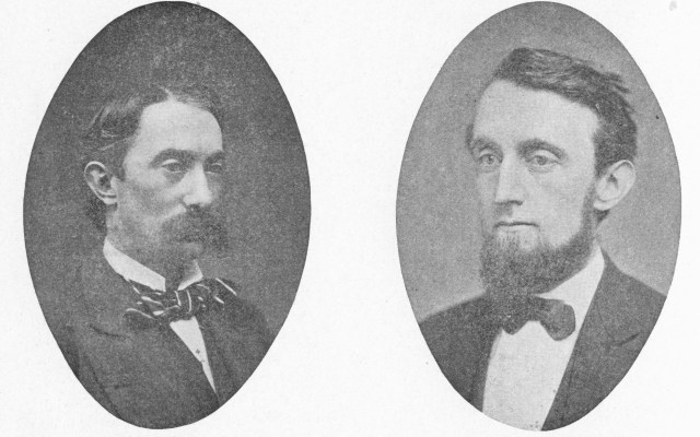
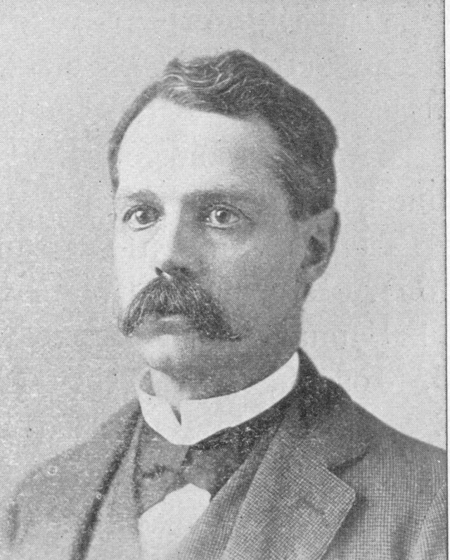
The brothers William Wirt Warren and Webster Warren and their respective families lived near the top of Academy Hill Road. William Wirt Warren was elected to Congress in the late 1860s, while his brother Webster served as Town Treasurer for many years. William Wirt was also the most prominent member of the so-called “Brighton Ring” that masterminded the 1874 annexation of Brighton to the City of Boston. It was a nephew of the brothers Warren, George W. Warren, who founded in 1885 the Brighton Item (later called the Citizen-Item), a local weekly newspaper that was published for over a century.
The Warren Family and Academy Hill: The Warren family dominated Academy Hill. The Warren houses stood at the crest of the hill. Congressman William Wirt Warren was the prime figure and attorney for the so-called “Brighton Ring.” He died at the relatively young age of 49 but had a profound long-term influence on the character of Brighton. His son Bentley Warren attended the Boston Latin School. Bentley Warren’s closest friend there was the future philosopher, George Santayana, who often visited the Warren House on Academy Hill. Another close friend from Bentley’s days at Amherst College was James Garfield, Jr., son of President James Garfield, who likewise was a guest at the Warren house on several occasions.
Descend Academy Hill.
Stop 12: Vantage Point: The bottom of Academy Hill Academy in front of the Hathaway Mansion
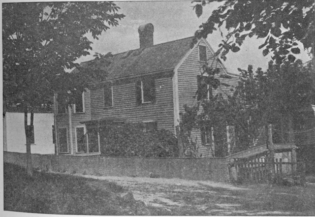
 The Nathaniel Jackson House stood to the immediate right of the Holton Library at the intersection of Academy Hill Road and Chestnut Hill Avenue on the site now occupied by the Brighton Municipal Court House.
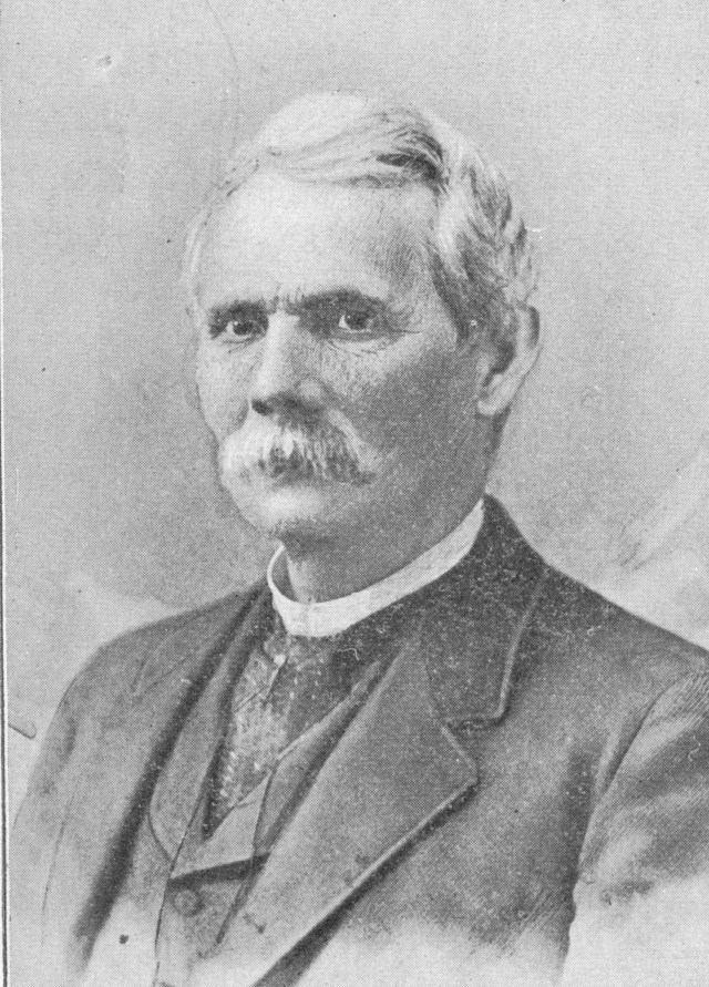
Nathaniel Jackson and his twin brother, Samuel Jackson (who doubled as a horticulturalist), owned and operated slaughterhouses on Chestnut Hill Avenue, about a quarter of a mile south of the present William Jackson Avenue intersection. When the Court House was built in the late 1920s, the Nathaniel Jackson House was moved over to Winship Street, where it still stands, directly opposite O’Neill Place.
 William Jackson, son of Samuel, was the City Engineer of the City of Boston for several years and oversaw the construction of the the Harvard Bridge across the Charles River. Brighton’s William Jackson Avenue, which extends up the east side of Academy hill from Chestnut Hill Avenue was named for this prominent engineer.
Proceed along Academy Hill Road onto Peaceable Street.
Stop 12: Peaceable Street.
 Peaceable Street & the Smith-Winship House. The Smith-Winship House, at 17-19 Peaceable Street, dates from about 1720, and may well be the oldest surviving building in Allston-Brighton. Its occupant prior to 1769 was Ebenezer Smith, a well-to-do farmer who owned a 200 acres property that extended both north and south of this residence. In the early 1770s this farm was acquired by the Winship family—Jonathan Winship I and II, the father and son team that in 1776 founded the Little Cambridge Cattle Market (the Brighton Cattle Market after 1807). In this house, which still stands, were born several of the brothers who engaged in the Pacific trade in the 1797-1815 period, most notably Captain Jonathan Winship, who upon returning from the Pacific in 1820, also founded the local horticultural industry.
 This 1850 portrait of Captain Jonathan Winship, is in the collection of the Brighton-Allston Historical Society, a gift to the society by Winship descendants.
Later occupants of the Smith-Winship House included the Reverend John Foster and his wife, the novelist Hannah Webster Foster, who lived here briefly prior to the construction of the First Church Parsonage, which we’ll be seeing shortly.
After viewing the Smith Winship House proceed to the far end of Peaceable Street and turn left onto Winship Street. Walk to the intersection of Winship and Washington Streets, facing the District 14 Police Station.
Stop #14 – Vantage Point: Corner of Winship & Washington Streets

The Winship Mansion, built by Jonathan Winship II in 1780, stood on the site of the present District 14 Police Station at the eastern end of the center. In 1820 the mansion was sold to Samuel Dudley, who expanded the building and converted it into the Brighton Hotel.
The Winship Mansion was built with the substantial profits that the Winships earned from their cattle and slaughtering enterprises. The building stood at the center of an extensive estate, much of it previously the property of Ebenezer Smith (they had lived in the relatively small Smith farmhouse prior to moving to this far more commodious and elegant dwelling. The Winship family occupied this house for forty years.
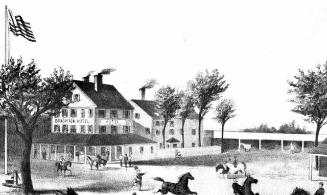
The Brighton Hotel, the remodeled Winship Mansion.
In 1820 the Winship Mansion was sold to Samuel Dudley, who expanded it and turned it into a hotel, the Brighton Hotel, the town’s largest hostelry before the construction of the first Cattle Fair Hotel in 1830.
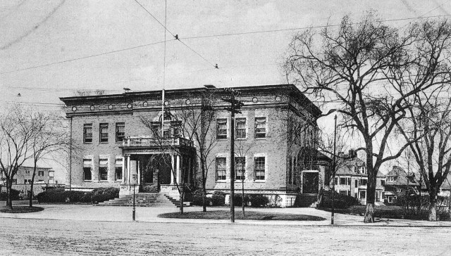 The Brighton Police Station, dating from 1894, occupies the site where the Winship Mansion and Brighton Hotel once stood.
The Brighton Police Station, 1894: The Brighton Hotel was taken down in the early 1890s and was replaced in 1894 by the Brighton Police Station. The architect of this handsome Renaissance Revival style, which has undergone some serious renovation over the years (the original elaborate portico has been replaced), was designed by Edmund March Wheelright, one of America’s greatest municipal architects. whose other structures of note near Boston include the Longfellow Bridge, Horticultural Hall, and the New England Conservatory of Music. Brighton contains no less than four major Wheelwright structures, two of which have been designated official City of Boston Landmarks.
Looking east:
At the eastern end of Brighton Center, on the crest of Nevins Hill, stands St. Elizabeth’s Hospital. The original building, pictured here, a distinctive Spanish Mission style structure, was demolished in the 1980s to make way for the existing modern edifice. The original building was considered one of the finest examples of the Spanish Mission style of architecture in Boston and its demolition was a great architectural loss to the community.
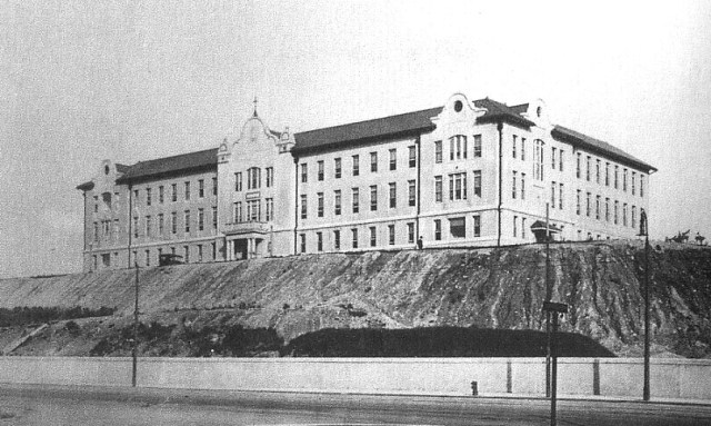
An early photo of St. Elizabeth’s Hospital, taken just after the completion of the original building in 1912 before the grounds had been fully landscaped.
St. Elizabeth’s Hospital: St. Elizabeth’s Hospital moved to Brighton from the South End in 1912. This edifice dominated the western approach to Brighton Center (an aesthetic amenity of the first order). It was replaced by the massive yellow brick Madeiros Pavilion in the mid-1980s.
Looking southeast along Washington Street:
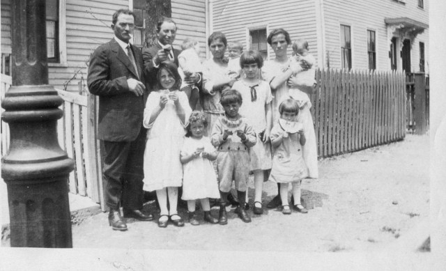 Italian immigrant families on Snow Street in the Buggs Village neighborhood in 1925
Buggs’s Village: The neighborhood to the immediate southeast of Brighton Center, known as Buggs’s Village, an area enclosed by Winship Street on the west, Monatery Road on the east, Washington Street on the north and Union Street on the south, became the chief Italian immigrant enclave in Brighton in the 1900 to 1930 period. Italians were, initially at least, drawn to the location by the job opportunities offered by an Irish contractor named John “Buggs” Behan, who resided on Shannon Street and ran a boardinghouse populated by immigrants next to his residence. Behan offered employment to immigrant masons, bricklayers, and laborers. The area acquired its somewhat inelegant name from Behan who owned a Concord coach, or buggy, which he is said to have been in the habit of driving sometimes recklessly through the streets of the town. He was thus referred as “Buggs” Behan. While the neighborhood was not exclusively Italian in ethnic makeup, there being an admixture of Irish and Yankee families in the neighborhood, it nonetheless contained the heaviest concentration of persons of Italian ethnicity in Brighton, and offers an example of the tendency of newly arriving Italian immigrants to cluster not only by nationality, but by place of origin in Italy, a high percentage of its residents having come here from the mountainside village of San Donato val di Comino in the Lazio region of the peninsula.
The Brighton Five Cent Savings Bank:
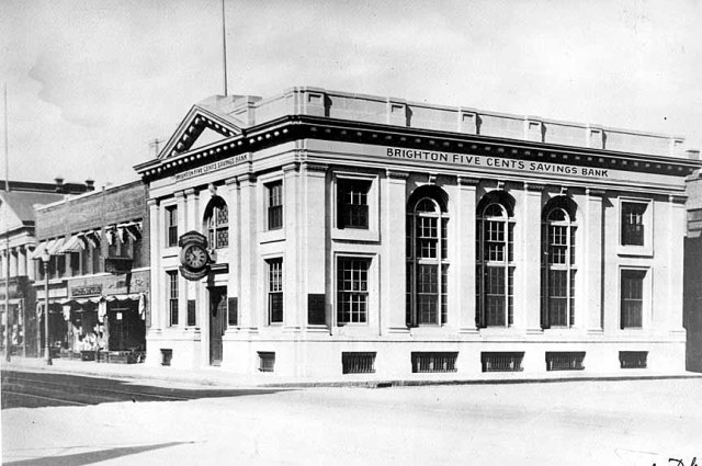 The neo-classical style Brighton Five Cents Savings Bank, dating from 1912, was one of the handsomest buildings in Brighton Center in its day, but has unfortunately been “improved” and its neo-classical hidden.
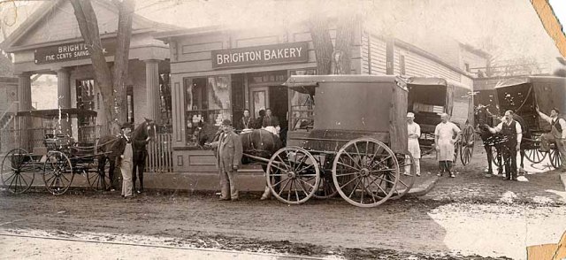 The original headquarters of the Bank of Brighton, founded in the late 1820s, stood on the south side of Washington Street, opposite the Warren building, and next door to the Brighton Bakery, as seen in this circa 1885 photograph.
Stop 15: Washington Street, eastern end, between Winship Street and Academy Hill Road.
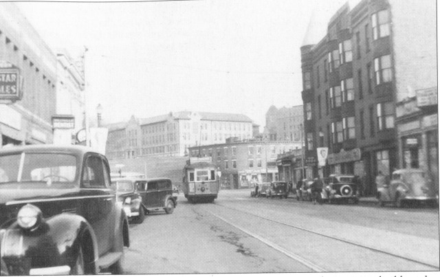 The Nagle Building: On the site now occupied by the Winship Spa, at the corner of Winship and Washington Streets, once stood the Nagle Hotel (later the Ftzgerald Hotel). In the 1890s demolished the hotel and constructed the existing building handsome Queen Anne style building seen to the right in this photo dating from the late 1930s. This photo, , also shows a commercial and residential building that once stood at the foot of Nevins Hill. In the background to the left one sees the facade of the 1912 Brighton Five Cents Savings Bank.
The 1939 Post Office Building: To the west of the Nagle building stands a building that once accommodated the Brighton Post Office. Note that the buildings cornerstone identifies it as a post office and furnishes information about its date of construction.
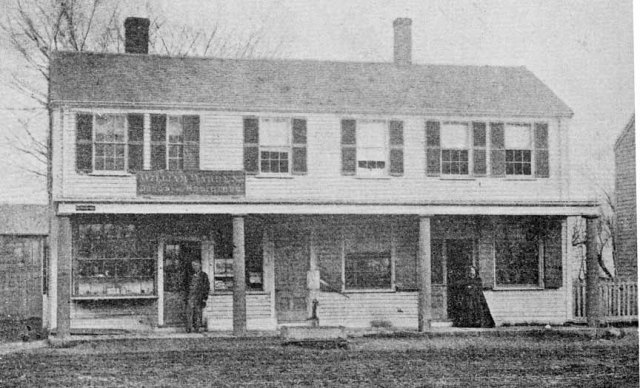
The William Warren Drug Store, the oldest commercial establishment in Brighton Center, dating from before 1811 stood on the north side of Brighton Center, on the site now occupied by the Warren Building.

This large Renaissance Revival style structure, the Warren Building, was built in 1879 by members of the Warren Family. The Warrens had owned this land for decades. The The wooden building housing the Warren Store was taken down to make room for this multi-srory edifice with a meeting hall, called Warren Hall, on its top floor. Warren Hallwas a popular venue for banquets and political rallies. The Warren Building also housed the offices of the Brighton Item, founded in 1884, the community’s weekly newspaper, edited by George W. Warren, nephew of William Wirt and Webster Warren (see above). The paper, later known as the Allston-Brighton Citizen-Item, suspended publication in the late 1980s, having existed for over a hundred years.
The Original Town Hall Site & The Egyptian Theater:
Here, on the site of the Elks Lodge, once stood Brighton’s original town hall, the old Little Cambridge meetinghouse, which was moved here in 1807, to serve the community’s newly established town government.

Brighton’s Egyptian Theater, established in 1929, later also stood on the site of the Brighton Elks headquarters, on the south side of Washington Street a short distance east of the Academy Hill intersection. Here we see the theater as it looked in 1929, at the time of the opening.

An interior view of Brighton Center’s elaborate Egyptian Theater
In 1929 the Egyptian Theater, one of Boston’s great suburban movie palaces, was constructed on this site, a work of the noted architectural firm of Eisenberg & Feer. With the rise of television in the 1950s, this 2400 seat theater closed its doors in 1958 and was subsequently demolished.
To the immediate west is the oldest restaurant in Brighton Center, Mandy & Joe’s, founded in 1948. Prior to 1948 this building accommodated the popular Puritan Luncheonette.
The Brighton Town Hall, 1841:
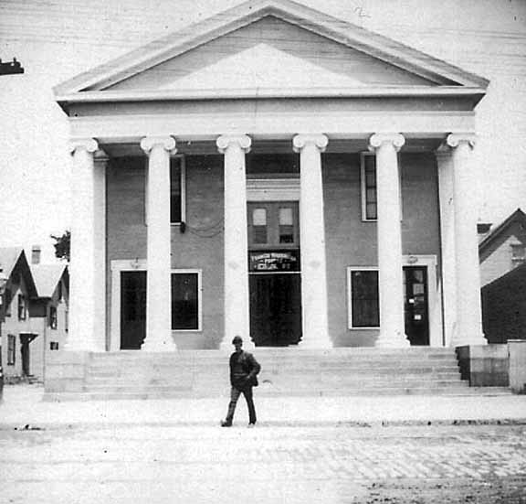
Brighton’s handsome Greek Revival Town Hall, dating from 1841, stood at the corner of Washington Street and Waldo Terrace, on the site now occupied by the Knight’s of Columbus Hall.
In 1841 the town replaced its original town hall with this handsome Greek Revival style edifice designed by prominent Boston architect Richard Bond, and built by local master carpenter/ craftsman Granville Fuller, father of the architect George Fuller, who designed the 1873 Holton Library and also the 1866 Brighton Congregational Church. With the annexation of Brighton to Boston in 1874 (a decision that that was made in the 1841 Town Hall), the building assumed the function of a combination police station and courthouse, until new structures were provided for these purposes in 1894 and 1927 respectively. The superstructure of this building was razed in the late 1970s, but its distinctive granite foundation was incorporated into the Knight’s of Columbus Hall that replaced it.
The Rockland House Hotel: This building, located at the southeast corner of Washington Street and Academy Hill Road, was one of six hotels that once existed in the Brighton Center area. It was then called the Rockland House, since lower Academy Hill Road was then a part of Rockland Street and prior to 1871 had also been the main road into Brighton Center from the south. The Rockland House Hotel dated from about 1870. For several decades (into the 1960s) it accommodated Picone’s Drug Store.
Stop 13: A key Literary Landmark: The First Church Parsonage, Academy Hill Road, c. 1788

The Fist Church Parsonage, dating from the late 1780s, the home of the Reverend John Foster and his wife, the author Hannah Wevster Foster, an important literary landmark. Sadly, no historic view of this important building is known to exist.
First Church Parsonage: One of the most interesting and historic buildings in Brighton is this much-altered structure, which was built in the late 1780s as a residence for Brighton’s first regular minister, the Reverend John Foster and his wife, Hannah Webster Foster. It was in this house in 1797 that Hannah Foster penned the first novel written by a native-born American woman, The Coquette, or The History of Eliza Wharton, which was said to be, next to the Bible, the most popular reading material in the America of that period. The Coquette has appeared in over forty editions over the years and is still being read in college literature classes. Later Mrs. Foster wrote a second novel while a resident here, The Boarding School (1799), after which she abandoned her literary career and turned her efforts to the business of being a minister’s wife. She is reputed to have organized the first women’s club in Massachusetts among the parishioners of Brighton’s First Church. The Fosters, however, had two daughters that followed in their mother’s footsteps and became novelists. This ancient and venerable structure, one of the stops on the Brighton-Allston’s Women’s Heritage Trail, has seen many unfortunate alteration over the years, including a commercial addition to its Academy Hill Road facade.
 The Brighton Market Bank, and a general store belonging to Charles Heard, the first store in Brighton to sell first ready-made clothing, stood east of the Harvard (now Argus Place) a dead end street on the south side of Brighton Center.
Stop 16: Market Street near Brighton.

This combination commercial and residential building, which once stood directly behind the Washington Building on Market Street (a site that is now a parking lot) housed the community’s first motion picture theater, The Brighton Theater, established in the early 1900s, before the introduction of talking movies.
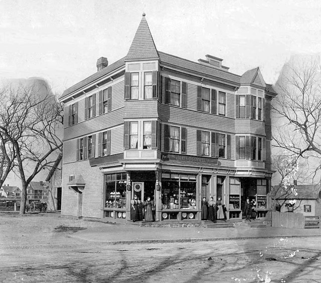
Here we see another long-departed commercial/ residential structure. This building stood at the northwest corner of Market and Surrey Streets. It was built in the early 1890s by James O’Connell, a plumber, who ran his business out of one of its two street level storefronts. The other storefront was occupied by an undertaker named James L. Muldoon. The photograph dates from the early 20th century. Note the streetcar tracks in front of the building. At that point a streetcar ran down Market Street from Brighton Center connecting o Western Avenue. This streetcar line was described by John McLane in my interview with him, published elsewhere on this blog.
On a personal note, I offer these additional details and memories of this building, which was not finally taken down until the 1960s. My grandparents, Loreto and Cesidia Salvucci moved here from O’Neil Place in Bugg’s Village in 1938 or ’39 and lived on the second floor apartment for several years, and my parents, who were married in 1941, had their first apartment on the third floor. The owner at that point was another plumber, a Mr. Monahan, who utilized the large barn at the rear of the property as a workshop and storage facility. After I was born at St. Elizabeth’s Hospital in January of 1942, I also lived here briefly (for about six months), before the entire family moved to 36-38 Kenrick Street in July of 1942, where I grew up. While I was of course too young to have any memories of the building from my grandparents and parents period of residency, I do remember baby-sitting my first cousin Amy Magnarelli here in the early 1950s when her parents, Donata and Dan Magnarelli, occupied one of the building’s reconverted and drafty storefronts during the severe housing shortage of that period. WPM

Hi Bill,
It’s always a great educational experience and pleasure reading your articles.
Hope all is well with you and Mary Ann.
Will you be coming north to Boston anytime soon?
I hope so.
Nancy O’Hara
LikeLike
Thanks, Nancy. I thought this material should be made available to anyone who wants to walk the Brighton Center area. Hopefully, some will take advantage of the postings. Yes, Mary Ann and I will be spending a few days, September 16, 17, and 18th, in Boston. We’ve arranged to have dinner with Charlie, Carol Boggs, and May Tocci on the evening of the 18th (I understand Charlie and Mary) are going to be up in New Hampshire that weekend).. We’d love to have you and Mike join us on the 18th, if you’re available. I’m not sure what restaurant, probably something local.
I also asked Mary about visiting the museum and she said it’s only open a couple of days a week. I believe she said Friday is one of the days, but we’re coming in on Saturday afternoon. We going to be on the Cape from the 9th to the 16th, and will be arriving in Brighton probably about noon on the 16th. I’d like to see the Barry’s Corner exhibit, if access to the Museum on an off day is possible. Perhaps we could get together then.
Best Wishes,
Bill
LikeLike