
1. The North Atlanta and Marietta Streetcar Line, 1905-47
With the introduction of electric streetcars into the City of Atlanta in 1889, a process of rapid extension of streetcar service to the suburbs was set in motion.
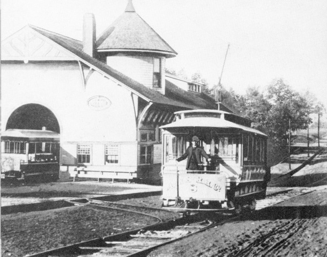
 Not until 1905, however, was Electric streetcar service extended through Smyrna by the North Atlanta and Marietta Streetcar line. The line emanated from Atlanta’s Five Points, crossed the Chattahoochee running along Atlanta Road through Smyrna and terminated in downtown Marietta. It ran on its own right-of-way on the east side of Atlanta Road. Here we see one of its streetcars delivering passengers at the end of the line in Marietta Square adjacent to Glover Park. The horse-drawn vehicles lined up along the side of the streetcar presumably provided taxi service to more remote locations.
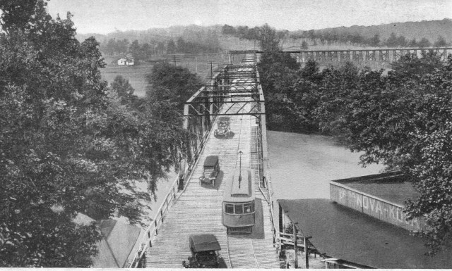 This postcard view shows an electric streetcar and several motor vehicles crossing the Chattahoochee River Bridge into Cobb County about 1930.
 Electric streetcar service did much to foster Smyrna’s early development from an agricultural village into a bustling suburb in the 1905 to 1930 period. Here we see the Creatwood stop on the line, one of almost fifty designated stopping points. This handsome shelter stood in front of the Brawner Hospital (now Brawner Hall). A number of additional shelters were provided along the route for the accommodation of passengers. This streetcar line provided a relatively inexpensive and efficient mode of transport for Smyrna residents, in an era when not every resident owned an automobile, with downtown Atlanta only about 45 minutes away and Marietta Square about 20 minutes away.
 The Springhill stop on the Streetcar line into Smyrna

The North Atlanta and Marietta Railway Depot in Downtown Smyrna after its conversion to commercial uses in a photograph probably dating from the 1970s. No image of the building as it originally looked is known to exist.
 A streetcar stops at the East Spring Street intersection in Downtown Smyrna in 1946.
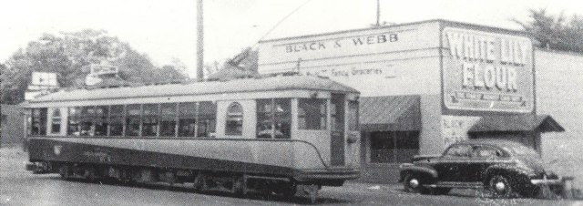
 The last trip on the line, pictured here, occurred on January 31, 1947. By the mid-1940s, as automobile ownership became virtually universal, ridership was falling off and the line was losing money.
 A Greyhound Bus Route replaced the streetcar on the Atlanta Road route in the late 1940s.
2. Early Motor Vehicles
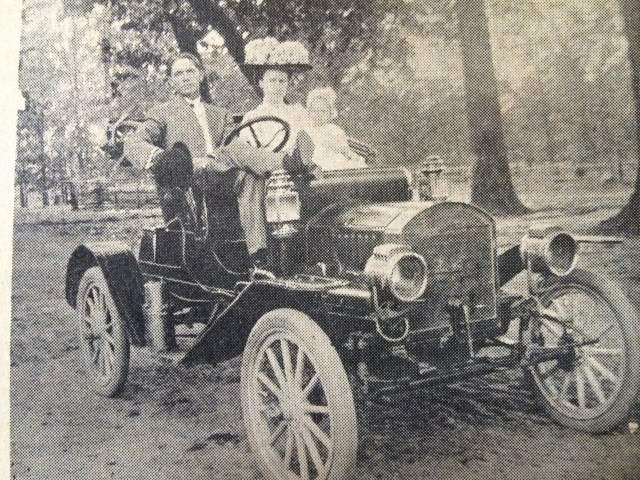
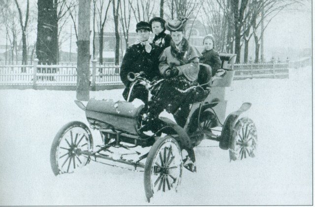 The first automobile to pass through Smyrna did so in the winter of 1902-03 on its way from Atlanta to Marietta. The car in question was an Oldsmobile belonging to Otis and Ida Brumby, who are seen here with their children in Marietta Square.
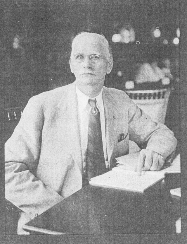 Dr. William T. Pace, Smyrna’s sole physical, was the first Smyrna resident to own an automobile, c. 1905. Dr. Pace also owned a drug store in the downtown, served as Mayor of Smyrna in 1912, and represented the Smyrna area in the Georgia State Legislature for several years.
 A 1911 Baby Maxwell Automobile, which had recently been purchased by Mr. A. C. White for his rural free delivery route is shown here. Mr. White received $50 a month from the Postal Department to service his RFD route. He is seen here with his wife and daughter.
 Here we see the dedication ceremony of the First Bank of Smyrna in 1911. The building stood on the west side of Atlanta Road in Downtown Smyrna. To mark the occasion, the name of the street that intersected Atlanta Road to the left of the bank building (formerly Ireland Street) was renamed Bank Street. The Downtown Redevelopment Project of the early 1990s eliminated this intersection. Note the single automobile that appears in this photo, testifying to the very small number of Smyrna residents who then owned cars in 1911.
 W. A. McBrayer and family members are seen here with his automobile about 1918. Mr. McBrayer was the local justice of the peace in Smyrna.
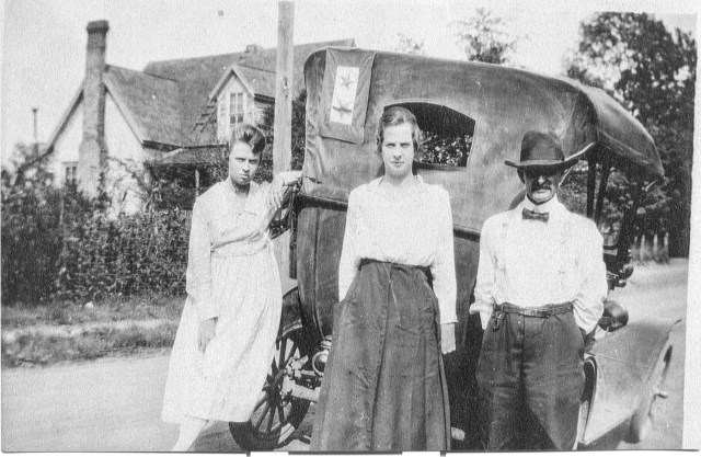
 Helen, Robert and Carl Terrell appear here at rest stop on the running board of the family car in 1926. Carl Terrell was raised on a farm on Terrell Mill Road. In 1906 he built a house for his widowed mother on Roswell Street near downtown Smyrna, where he later lived with his family. Mr. Terrell served in the late 1940s as a Smyrna City Council member and City Clerk. Readers are referred to the oral interview with Helen Terrell McGee (the little girl pictured here) that I conducted in 2012, when she was 91 years of age, which I recently posted on this blog.
3. The Dixie Highway and Tourism.
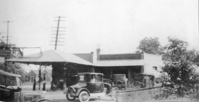
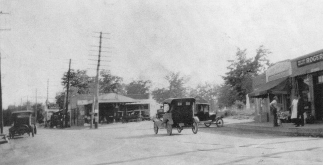 Automobiles on Atlanta Road, corner of Memorial Drive about 1920, with D.C. Osborne’s Garage at the center. By 1950 no less than seven gas stations/ garages will exist in Downtown Smyrna.

In the years following World War I Atlanta Road was incorporated into the Inter-regional Dixie Highway linking Florida to midwestern cities like Detroit and Chicago. Every year thousands of tourists, traveling on this roadway passed through Smyrna. The channeling of so many tourists through Smyrna was a major stimulus to the local economy. In 1938, however, with the construction of nearby Cobb Parkway, Georgia’s first four-lane roadway, the route of the Dixie Highway was altered to include the new roadway, thereby depriving Smyrna of much of that economic stimulation it had formerly enjoyed.
 A chain gang working on a stretch of the Dixie Highway.
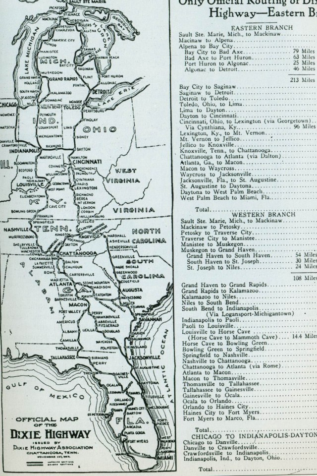 A Map showing the entire route of the inter-regional Dixie Highway that linked Florida to to mid-western population centers.
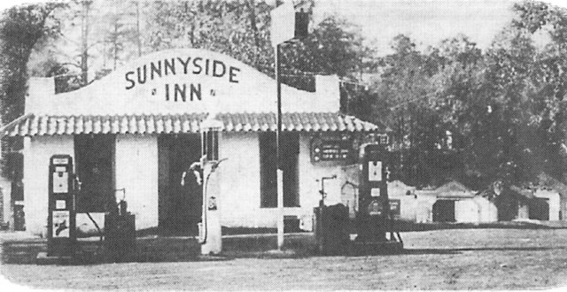 Tourist cabins, hotels, eateries, and service stations arose along the Atlanta Road segment of the Dixie Highway in the 1920s and 1930s to accommodate the route’s heavy tourist traffic. Here we see the Sunnyside Inn and cabins, located on the west side of Atlanta Road across from the Campbell Road intersection. With the decline of the tourist trade after 1938, these cabins are said to have been used for a variety of illicit activities.
 The Stonewall Cottages and Restaurant were located on the west side of Atlanta Road about two miles south of downtown Smyrna, opposite the intersection West Paces Ferry Road. The captions on the edges of this postcard provide interesting details about this hostelry—it was given a Confederate theme and offered steak and chicken dinners. The cabins and eatery were owned by Edgar R. Anderson, who also owned a liquor store on Concord Road in Smyrna.
 In the prohibition era, the Dixie Highway was a major artery in the illegal liquor trade, as this map illustrates. Georgia was the first state in the nation to adopt statewide prohibition of the manufacture and sale of alcoholic beverages in the 20th century, doing so in 1908, a full decade before the adoption of the 18th amendment (national prohibition). While prohibition came to an end in Georgia in 1935, the sale and consumption of alcoholic beverages was thereafter restricted or forbidden by most Georgia counties. Well into the 1960s residents of Smyrna and South Cobb desiring to purchase liquor were obliged to travel across the Chattahoochee into Fulton County to acquire a supply legally.
 The Guernsey Jug Restaurant on Atlanta Road which stood about a mile south of the Downtown advertised itself as “The best place to eat between Chicago and Miami.”
 The Guernsey Jug Restaurant, pictured here after it ceased to function as a restaurant, was established by the Crowe family, the owners of the Creatwood Dairy, and was situated on the Crowe property.
4. Filling Stations and Car Repair Facilities
 D.C. Osborne’s Smyrna Garage stood at the corner of Atlanta Road and Memorial Drive in Downtown Smyrna.
  The work crew at D. C. Osborne’s Smyrna Garage in the late 1930s.
 A side view of D.C. Osborne’s Smyrna Garage.
 Glover’s Store and Filling Station on Atlanta Road at the Camp Highland Road intersection in Oakdale, about 1930
 Jake Smith’s Service Station, on Atlanta Road at the Young Street intersection in Oakdale.
 The Anchor Filling Station stood on Atlanta Road at the southwest corner of West Spring Street next to the entrance of present-day Market Village.
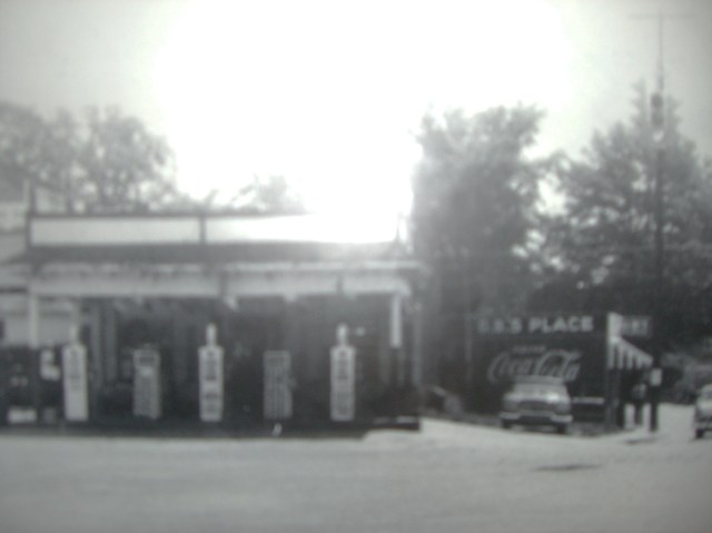 Fouts Filling Station and Auto Repair, dating from 1948, stood at the northeast corner of Atlanta Road and East Spring Street, on the parcel of land that is now Fouts Park. Note its relationship to G.B.’s Place Restaurant at the corner of Wast Spring and Roswell Streets.
 The Walker Motor Company, founded in 1948, stood on the east side of Atlanta Road near the site now occupied by the Smyrna Museum.
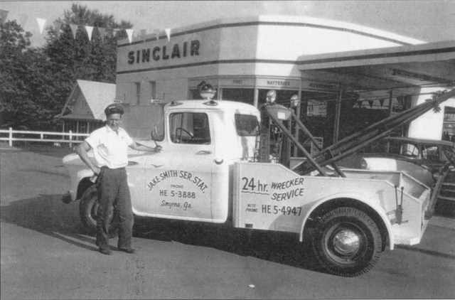
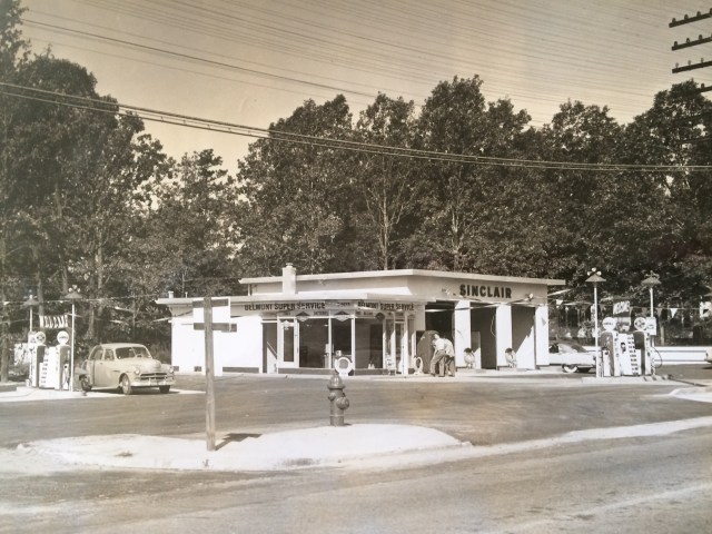 The Sinclair Service Station, constructed in 1953, stood at the corner of Atlanta Road and Cherokee Avenue (now Windy Hill Road).
5. Satellite Shopping Centers. The proliferation of automobile ownership and a dearth of adequate parking facilities in the congested downtown led to the establishment of satellite shopping Centers in the Post-World War II period.
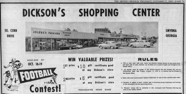 The Dickson Shopping Center, which still exists, is situated at the southwest corner of South Cobb and Concord Roads. Smyrna’s oldest satellite shopping center it was established by entrepreneur T.L. Dickson.
 Belmont Hills Shopping Center at the intersection of Atlanta Road and Windy Hill Road was founded in 1954. Its chief developer was businessman Bill Ward, for whom Smyrna’s Ward Street was later named. During World War II Ward headed the American Bantam Car Company which introduced the Jeep automobile to the world. At the time of its opening the Belmont Hills Shopping Center was reputed to be the largest shopping Center in the southeastern states.
 The Jonquil Plaza Shopping Center, more modest in dimensions, was laid out on the east side of Atlanta Road just south of the old downtown in 1957. While some of the downtown merchants moved to this new location it did not solve the downtown’s fundamental problem of congestion and outmoded facilities. The prime mover in its establishment was J. D. Daniel.
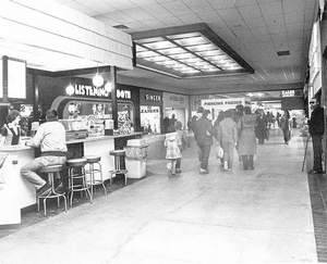
 The Cobb Shopping Center on South Cobb Drive, which included a local branch of Rich’s Department Store, the building that now houses the Smyrna International Academy.
The Cumberland Shopping Mall on Cumberland Boulevard which opened in the early 1970s
6. Traffic Congestion and Parking Problems in Downtown Smyrna
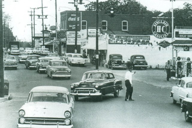 The east side of Atlanta Road in the mid-1950s. The gas station to the extreme right was the Fouts Brothers Station (see above).

A map of downtown Smyrna prepared in 1952 by a class of Georgia Tech design students under the direction of noted architect and city planner Isaac Saporta. The commercial heart of Smyrna then consisted almost entirely of small-scale structures (essentially store fronts) strung out along a single heavily-traveled two-lane roadway which backed up on its eastern side to railroad tracks. The area suffered from mostly outmoded structures and a dearth of parking spaces. The widening of Atlanta Road, a measure that every mayor of Smyrna since the 1930s had identified as his or her primary goal, was not finally accomplished until the late 1980s during the administration of Mayor A. Max Bacon when the downtown commercial strip was demolished and was replaced by a modern complex of handsome buildings. For further information on old Downtown Smyrna readers are referred to my recently posted Smyrna Photo Essay #3: Smyrna’s Old Downtown..
 A row of Downtown Smyrna small-scale and outmoded commercial structures.
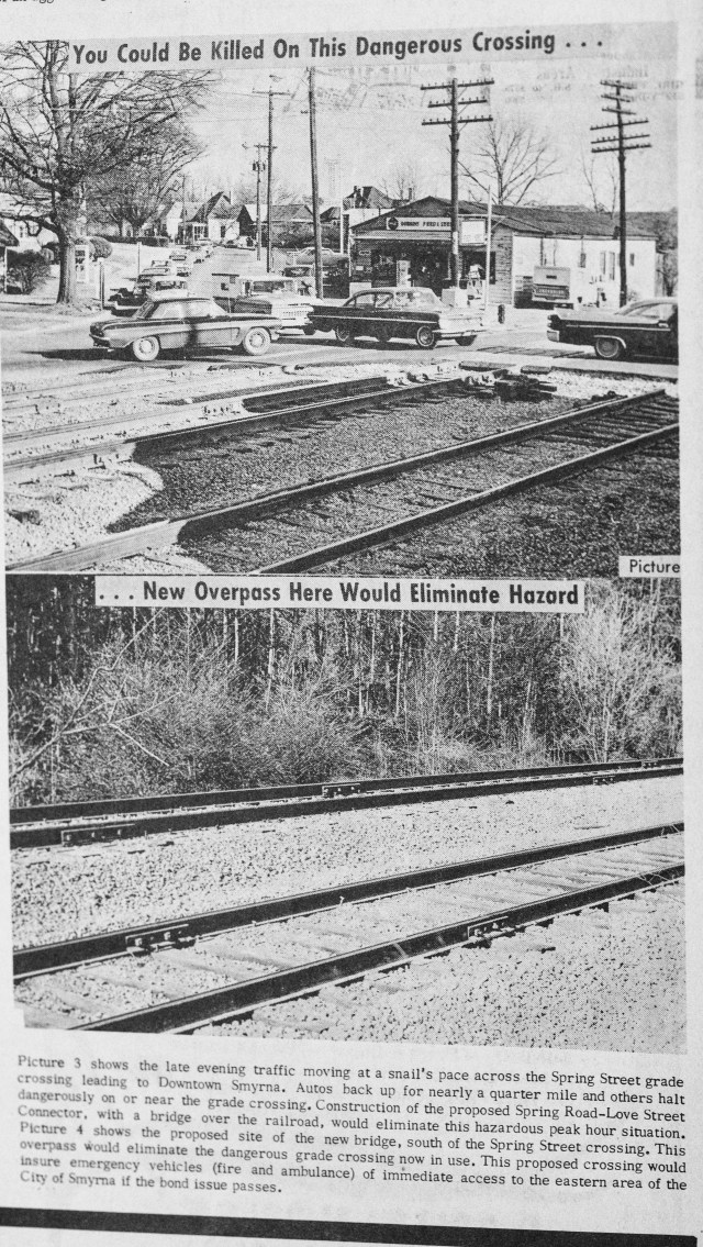 Prior to the early 1960s traffic heading east out of the downtown Smyrna accessed Spring Road via East Spring Street and thus through the present Williams Park Neighborhood, which resulted in much traffic congestion during both the morning and evening rush hour periods.
 An overpass was constructed over the railroad tracks opposite what is now the Concord Road intersection with Atlanta Road. This overpass provided direct access to Spring Road, which was widened and improved, and to the Cobb Parkway beyond. These images show the improvements made on Spring Road near its intersection with Cobb Parkway.
 Accidents frequently occurred at railroad crossing points in the downtown. The Hawthorne Street crossing was particularly dangerous.
6. South Cobb Drive – Smyrna’s Developmental Focal Point after 1943
With the construction of South Cobb Drive in 1943 (originally called The Access Highway), the road to the newly established Bell Bomber Plant in Marietta, a facility that at its height employed nearly 30,000 workers, the locus of development in the Smyrna shifted away from the historic Atlanta Road corridor to this new highway lying two miles to the west.
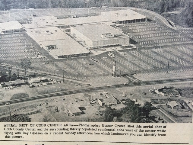
 In the 1950 to 1970 period Smyrna’s population increased from 2,000 to over 17,000 while its boundaries expanded to encompass the new neighborhoods that were developing adjacent to South Cobb Drive. The above article, which appeared in the Smyrna Neighbor newspaper in 1968, evidences the dramatic shift in the locus of development that occurred between 1950 and 1970.
 The main parking lot at the Bell Bomber Plant in Marietta where nearly 30,000 men and women worked during World War II. Many of these automobiles reached Bell Bomber via the Access Highway, as South Cobb Drive was originally known. Bell Bomber closed at the end of World War II, but was replaced by Lockheed plant in the early 1950s during the Korean Conflict.
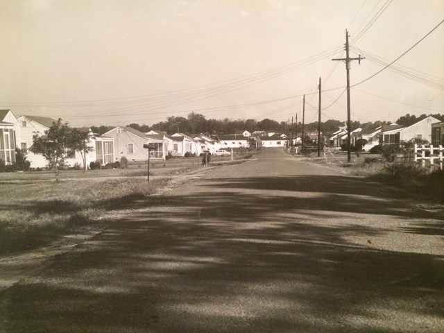 Here we see a typical residential subdivision just off of South Cobb Drive—the Green Acres development near Pat Mell Road in a photograph dating from 1953.
 South Cobb Drive quickly became Smyrna’s principal commercial artery. Smyrna Tire, founded in 1973, stood at the intersection of South Cobb and Powder Springs Street.
 South Cobb Drive was carrying so much traffic by the early 1960s that it required widening. This photo shows the portion of that roadway lying between Windy Hill and Pat Mell Roads being widened from its original two to three lanes.
 South Cobb Drive being widened to four lanes in the 1970s.
