
The following images of Smyrna’s Old Downtown are arranged in approximate chronological order. Smyrna’s downtown was largely demolished in the 1989-90 period to allow for the widening of traffic choked Atlanta Road. Please bear in mind that the age of the buildings pictured here cannot be established with absolute certainty in every instance. Nor is this a complete collection. It is hoped that more images will be added over time. If any reader has access to additional pictures of downtown landmarks, or can offer details as to the age of any of the buildings, please send that information along so that appropriate alterations can be made. – WPM
Part 1: Before 1940

The Gateway entrance to the Smyrna Memorial Cemetery. This graveyard on Memorial Drive was laid out by the Methodists on the land that was part of the Smyrna Campground. The graveyard stood adjacent to the original Methodist Church building, constructed in 1846. The cemetery is said to date from 1838, but the oldest grave dates from 1846, the year that the first Methodist Church was constructed at this location. The gateway was constructed in the 1960s, with donations solicited by Smyrna’s first historian Mazie Whitfield Nelson.

Sedgefield Estate, the home of E.D.L Mobley, a member of Smyrna’s first city government. The photograph dates from the early 1880s, but Mobley was raised here. Thus the house is almost certainly an ante-bellum structure. This is the only image of a pre-Civil War structure that stood in the area of the old downtown known to exist. Sedgefield Estate comprised nearly 17 acres, extending from the north side of West Spring Street (today’s Market Village) to the vicinity of the Smyrna Police Station. Most of Smyrna’s major government buildings now sit on this acreage. Mobley was a realtor with offices in Atlanta. He commuted to his office daily by train.

An 1872 map of Smyrna’s downtown, produced in the same year that the small city was officially incorporated by the State Legislature. At that point few buildings existed in the downtown area: the Smyrna Academy building, the Methodist Church (rebuilt in 1869, having been burned during the Civil War), and the recently constructed Smyrna Depot (also dating from 1869) were the only major structures in the downtown Smyrna of that day.

The Smyrna Academy building as it appeared after its conversion to use as a public school. While the building is labeled “Smyrna High School”, it in fact, accommodated all grades.
A pencil drawing of the 1882 Methodist Church, situated adjacent to the Smyrna Memorial Cemetery, the building which which replaced the earlier 1846 and 1869 Methodist Churches. This is the building that will later be converted into the Smyrna Hotel and moved to the edge of Atlanta Road adjacent to the D.C. Osborne Garage.

The First Baptist Church, dating from 1884, stood on Atlanta Road at the northern corner corner of Powder Springs Street. A 1924 fire destroyed this building, whereupon the congregation moved to a lot at the corner of King and Church Streets.
 Legg Hall stood at the southern corner of Atlanta Road and Powder Springs Street adjacent to the 1884 Baptist Church. It was used for a variety of purposes, as a meeting place for the Nelm’s Masonic Lodge, and as a school house. Here we see a class taught by Mr. Mizell at this location in 1895.

A Pace Family Reunion in 1900. The Pace Homestead stood on the east side of Atlanta Road opposite the Church Street intersection, on land that now forms part of the Jonquil Plaza. The gentleman with the hat on his lap in the front row, John T. Pace, was the first of three Pace family members who served as Mayor of Smyrna, John T. Pace.
 The downtown did not begin to experience significant commercial development until the after the Civil War. An 1873 article in an Atlanta paper identified four stores as existing in downtown Smyrna at that juncture. The largest commercial building constructed in downtown Smyrna (a two story Italianate structure) was the Whitfield General Store, dating from the 1880s, which stood on the east side of Atlanta Road and backed up to the railroad tracks. The photo dates from 1912.
 This newspaper clipping identifies the figures standing in front of the Whitfield General Store in the above 1912 photograph.
 The W.N. Pace General Store stood at the southeast corner of Atlanta Road and East Spring Street.
 The 1907 Smyrna Depot stood on the tracks at East Spring Street, just north of the present Smyrna Museum Building, which replicates its appearance.

With a decline in the market value of cotton just after the turn of the 20th century, local agricultural production shifted to more profitable crops. Orchard products and berries took up the slack. Cobb County became a major producer of peaches. An 80 acre peach orchard was laid out on land just south of Spring Street and the Pearl Springs Cannery was established on West Spring Street in 1908 to process these new crops. Unfortunately, no contemporary image of the cannery is known to exist, but the building this large building was later converted into a headquarters for the Smyrna Police, and appears above.
 The Henry Gautschy House, built about 1908, to accommodate a distillery owner who had been displaced by the State of Georgia’s adoption of statewide prohibition. This Rhenish style residence was one of the first homes in Smyrna to be provided with indoor plumbing and electricity. It constructed of concrete blocks manufactured at the site of Mr. Gautschy’s former distillery, later the Bennett Farm, at the corner of Concord and King Springs Roads.
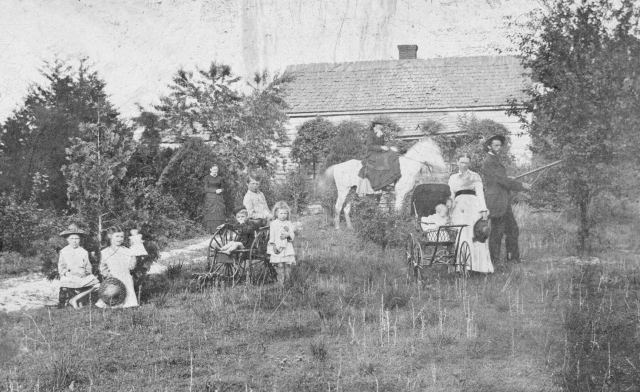
 The Konigsmark residence and adjacent coal yard stood on the east side of Atlanta Road, immediately north of the Pace House on land that now forms part of the Jonquil Plaza. Here we see Henry and Alma Konigsmark and their children on the grounds of their home, opposite the 1911 Smyrna Methodist Church. The Coal yard sat just south of the residence.
 The 1911 United Methodist Church building was situated at the northwest Corner of Atlanta Road and Church Street.
 The 1911 First Bank of Smyrna building was intuited at the northwest corner of Atlanta Road and Bank Street. Bank Street originally intersected Atlanta Road. Originally Ireland Avenue, the name of the street was changed to Bank Street at that time. The bank went out of business in 1926 and the structure later served as Smyrna’s City Hall for a time.
 In 1915 a fire destroyed a structure that stood just south of the W.N. Pace General Store, pictured above.
 A circa 1920 view of the intersection of Atlanta Road and Memorial Place. Notice Roger’s Grocery Store on the extreme left and The D.C. Osborne Garage in the triangle formed by the intersection at the center of the p[hotograph.
 In 1924, following a fire that destroyed the 1884 First Baptist Church (see above) a new Baptist Church was built by the congregation at the northeast intersection of King and Church Streets.
 The interior of Roger’s Grocery Store in the 1930s

Smyrna provided itself with a state-of-the-art new school building at considerable expense in 1920. Unfortunately it was extensively damaged by fire in 1924, but was immediately rebuilt. That structure, pictured here, stood on the west side of King Street opposite the present First Baptist Church.

This building, indicative of the small scale of municipal government, served as Smyrna’s City Hall in the 1920s and 1930s.
 Another view of the D. C. Osborne garage taken from the Memorial Place end of the property, c. 1925. About 1920 Atlanta Road was incorporated into the Dixie Highway, one of the nation’s first interstate roadways, linking Florida to Detroit. An increase in the volume of traffic through Smyrna followed. By the 1930s there were seven auto repair shops and filling stations in downtown Smyrna.
 Another view of D. C. Osborne’s Garage, with the owner standing in front. Mr. Osborne served on the Smyrna City Council in the 1930s. The building just beyond the Osborne garage, with the pillared portico, is the Smyrna Hotel, the converted 1883 Methodist Church, which catered to tourists passing through Smyrna on the Dixie Highway.
 Notably two of the five figures in this photo are African-Americans. Photographs of blacks were few and far between in this period.
 Pace’s Drug Store occupied the site on Atlanta Road near East Spring Street. Dr. Pace served as Mayor of Smyrna in 1912 and also represented the area in the Georgia State Legislature. Here occurred an incident involving Dr. Westbrook, the pharmacist pictured here, a challenge to racial segregation by returning World War I African American veterans that is described in detail in my book “A Brief History of Smyrna, Georgia.”
 John Stone’s General Store at the corner of Atlanta Road and Sunset Avenue, probably in the 1940s. The store had existed for some years prior to that date, but the precise date is uncertain. Sunset Avenue, which was on the line of the present Village Green, no longer exists.
 The Smyrna Women’s Club was chartered in 1925. In 1925 this active club bought a residence on the west side of Atlanta Road at the southeast corner of Powder Springs Street as a headquarters. In 1936 the clubhouse also housed a public library, which was supported during its first 25 years chiefly by private donations. The doorway to the right side of the building gave access to this modest library. Only in 1961 did the City of Smyrna provide itself with a purpose-built library structure on King Street. (see below)

The Streetcar Depot in Downtown Smyrna, situated on the east side of Atlanta Road a short distance north of the East Spring Street intersection.

Until the late 1920s, Smyrna residents depended on private wells for their water supply, a dependence that led to shortages during periods of drought, and that no doubt contributed to periodical outbreaks of disease. This problem was temporarily resolved in 1927-28 during the mayoralty of Patrick Edwards, when two deep wells were dug on the south side of Roswell Street, in what is now the Williams Park neighborhood, and a conduit constructed to carry an enhanced public water supply to a storage tank located just west of the Memorial Cemetery near King Street. This tower cost $2,800 to construct, at a time when the city’s annual budget was less than $10,000. With the rapid expansion of Smyrna’s population in the 1940s and 50s, this water supply system proved inadequate, and other measures were taken to provide an adequate water supply for the expanding city. The abandoned Smyrna Water Tower was finally dismantled in 1984. The building in the foreground is the Smyrna Fire Station.
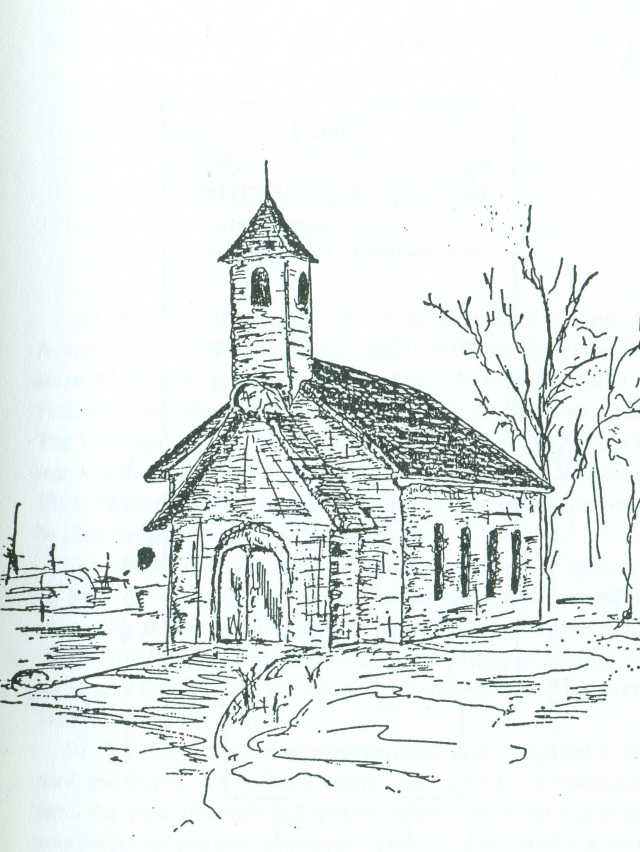
An hand-drawn illustration of the Smyrna Water Tower.
 Smyrna City Hall, 1933-59. This building, at the northwest corner of Bank Street and Atlanta Road, had originally housed the First Bank of Smyrna during the period 1911 to 1926. It was extensively renovated in 1933 to accommodate Smyrna’s city government.

Postmaster Zeland Wills in 1933. The post office was located on Atlanta Road next to City Hall. In 1933 there was no home delivery. Residents had to pick up their mail at the post office.
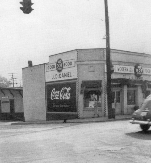 J.D. Daniel’s Red Dot Store at the corner of Atlanta Road and East Spring Street just west of the 1907 Smyrna Depot, c. 1935

A North Atlanta & Marietta streetcar in front of the Webb & Black Grocery Store at the corner of Atlanta Road and East Spring Street. This line connecting downtown Atlanta to Marietta Square via Smyrna operated from 1905 to 1947, and did much to stimulate the growth of Smyrna before the Great Depression set in in 1929. Black & Webb occupied the same site as the W.N. Pace General Store, and the dimensions and roof line of the building suggest that it was a remodeled version of the same building.
 An interior view of the Black & Webb Grocery Store, probably from the 1940s.
The Smyrna Trolley Depot, located on the east side of Atlanta Road, a short distance north of the of the East Spring Street intersection, is shown here as it looked after its conversion to other uses. The date of its construction is uncertain, but it
 A birds-eye view of Downtown Smyrna in 1936
 G.B.’s Place Restaurant, situated on the north side of East Spring Street, was founded in 1937

In the background of this photo one sees the Nelms House at the southeast corner of Church and King Streets, a ten room residence constructed by Dr. John Nelms in 1895. This house burned shortly after this photograph was taken in 1937.
 Here we see the first purpose-built Smyrna High School building, constructed in 1938 by the Works Progress Administration (WPA). The building, which still stands and is now part of the First Baptist Church complex, is located at the intersection of King and Stephens Streets.

Dr. G.C. Green (left) and Henry Konigsmark survey a lot just north of the Smyrna Memorial Cemetery in 1939 as a cleanup project for the Smyrna Men’s Club. The building across Atlanta Road to the left the Glover Service Station would later house the Walker Motor Company (see below) and stood on the site now occupied by the Smyrna History Museum.

The Smyrna Jail on West Spring Street in 1940.
Part 2: After 1940
 The Second Bank of Smyrna, new building, 1946

The Smyrna Presbyterian Church on Memorial Place, dating from 1913, across the street from the Smyrna Memoroal Cemetery, as remodeled in 1948.
 Walker Motor Company, Atlanta Road, founded in 1948, near the site now occupied by the Smyrna History Museum.
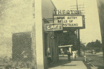 The Jonquil Movie Theater, established in 1948, which stood on Sunset Avenue near the southwest corner of Atlanta Road.
 Fouts Brothers Service Station at the northeast corner of Atlanta Road and East Spring Street, established in 1948.
 Dr. W. C. Mitchell’s Medical Office, constructed in 1948 at the Corner of Sunset Avenue.

Colonial Store Supermarket, Bank Street, 1951. Notice the building on the right under construction, Howard Hardware (see below).
 Hubert Johnson’s unique shoe shop on the west side of Atlanta Road in the downtown, where shoes were piled so high that customers had to go through the shop sideways.
 Shoemaker Hubert Johnson at work.

Map of downtown Smyrna, dating from July 1952, taken from the “A Survey of the City of Smyrna, Georgia Tech’s Planning Study No. 13.
 Davis Department Store, corner of Atlanta Road and East Spring Street, which existed from 1951 to 1959.
 Georgia Power building, North Atlanta Street, c. 1953
 Howard Hardware, Bank Street, c. 1953
 Smyrna Plumbing and Heating, c. 1953
 Rose’s Fashion Shop, c. 1953
 Smyrna’s Builders Supply, East Spring Street, c. 1953
 Reed Realty Office, Atlanta Road south of the East Spring Street intersection, c. 1953.
 Campbell High School Marching Band on Atlanta Street passing West Spring Street in 1953.
 In 1953 a crowd almost 4,000 Smyrna residents turned out for a Grand Remodeling Sale at Atherton Drug Store, which was located on the western side of Atlanta Road, near City Hall.

Downtown Smyrna, east side, looking north, 1956. Note should be taken of the old Whitfield General Store at the center of the image. Notice also the volume of traffic on Atlanta Road, a two-lane highway at that time.
 Downtown Smyrna looking north, c. 1956.
 Site of the Jonquil Plaza as it looked before the opening of the shopping center, c. 1956. The houses in the background are the Konigsmark and Pace houses.
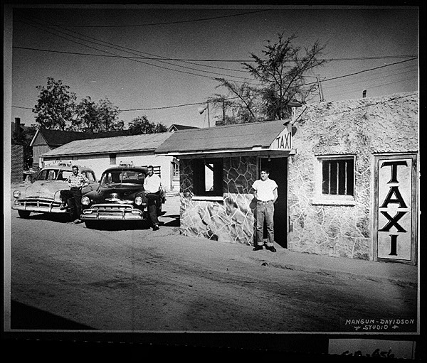 Taxi Service, West Spring Street, 1956
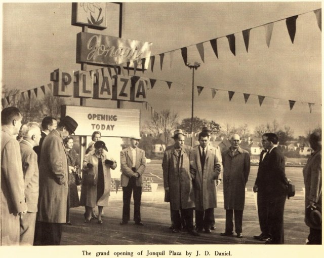 The Grand Opening of the Jonquil Plaza Shopping Center in 1957
 Smyrna Police Station, Atlanta at Bank Street (old bank building reconversion), 1958-70
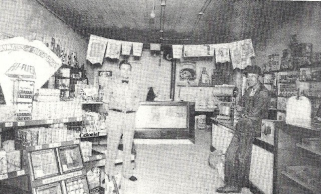 Interior of Atkins Grocery Store, corner of Bank Street and Atlanta Road
 Anchor Service Station, late 1950s, located in the triangle created by Atlanta Road and Memorial Drive
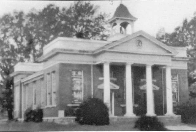
Smyrna City Hall Smyrna City Hall, 1959-1996, King Street
 Smyrna’s first purpose-built public library building was constructed on the south side of King Street south of the Smyrna Memorial Cemetery in 1961.
 The Smyrna Library as it appeared about 1975, after having undergone a facelift
 Proposed new look for Atkins Drug, 1970. Various proposals were made in 1970 to redesign the storefronts in the downtown in a Williamsburg style.
 TV Analysts Store, located at the corner of West Spring Streeet and Atlanta Road, 1974. This building took the place of several smaller stores, including Rogers Grocery Store and Hubert Johnson’s Shoe Repair. Note the Smyrna Water Tower in the background.
 The West side of Atlanta Road in Downtown Smyrna in 1978.

In an interview State Representative Bill Atkins, who owned and operated a store in the downtown for many years, and afterward purchased Atherton Drug, renaming it Atkins Drug Store, emphasized the former commercial vitality of the downtown and expressed regret at its demolition.
 Downtown Smyrna west side, 1980s.
 Save Old Smyrna (SOS) organization, 1980, includes future Mayor Max Bacon

I came to the area in the mid 60s and thankfully a lot of the old town was still in use.I fell in love with place and although my work took me elsewhere several times, I always returned. My children went through the Smyrna school system and eventually graduated from Osborne, which I consider Smyrna. I am posting the link on my wall so that local friends can see and enjoy it like I have.
LikeLike
My Grandfather, Emory Chastain, moved the family from the family farm in Kennesaw to Smyrna in the winter of 1940 right after my mother’s birth. The Smyrna home place sat on a track of land off Spring St at Jonquil. I’m uncertain how much property he originally owned, but I do know the property ran west toward the railroad tracks/Jonquil Plaza area and south toward the now Emory Ln/ Corn Rd area. The family ran a nursery there in Smyrna and also farmed the property in Kennesaw off of what is now Chastain Rd. They devolped some of the Smyrna property building the residential homes off of Emory Lane. Mother is number 9 of 11 children and graduated from Campbell HS in 58. As a child I remember frequenting the drug store fountain at Jonquil Plaza and browsing all the stores at Belmont Hills which was a shopping mecca at the time.
LikeLike
Dear Mr. Petty,
I am offering a series of six lectures on the history of Smyrna at the Smyrna Library on Monday evenings 6;30-7:30 beginning on February 5th and lasting until March 12th. The details appear on the Smyrna Public Library calendar, available on line if you’d like more details. I was wondering if you have any pictures of the Chastain farm that you would be willing to scan and send to me for use in the lecture series. We have very little in the way of historical images of the local farms here in Smyrna.
Many thanks for the comments you sent out last August about the Chastain property.
Best Wishes,
William P. Marchione, Ph.D.
Smyrna historian
LikeLike
The two men in the first photo of Part 2 — The Second Bank of Smyrna — look like my uncles (my mom’s brothers), Clifford and T.A. (Junior) Merritt, but I can’t tell for sure. They both lived in Smyrna at that time.
LikeLike
Its great to see the old pictures of the old town. I can remember from 1956 up.
LikeLike
Hi William, your photo essay on old town Smryna is one of the most comprehensive and complete collections I’ve seen. A dear friend of mine is opening a new restaurant in Smryna in less than a month and he wanted to put up pictures of old Smyrna throughout the restaurant. I was wondering if you could allow me to make prints of some of these pictures? It would be much appreciated!
LikeLike